IMAGES TAKEN NEAR TO
Waterbeach Road, SLOUGH, SL1 3JT
Introduction
This page details the photographs taken nearby to Waterbeach Road, SL1 3JT by members of the Geograph project.
The Geograph project started in 2005 with the aim of publishing, organising and preserving representative images for every square kilometre of Great Britain, Ireland and the Isle of Man.

There are currently over 7.5m images from over14,400 individuals and you can help contribute to the project by visiting https://www.geograph.org.uk
Image Map
Images are licensed for reuse under creativecommons.org/licenses/by-sa/2.0
Notes
- Clicking on the map will re-center to the selected point.
- The higher the marker number, the further away the image location is from the centre of the postcode.
Image Listing (4 Images Found)
Images are licensed for reuse under creativecommons.org/licenses/by-sa/2.0
Image
Details
Distance
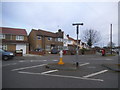
2

Waterbeach Road at the junction of Oatlands Drive
Image: © David Howard
Taken: 9 Dec 2017
0.20 miles
3
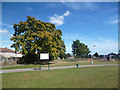
Godolphin Playing Fields
The northern boundary of a large tract of park and playing fields surrounded by suburban housing.
The unusual name comes from Dr. Henry Godolphin, 1648 - 1733, who was provost of Eton College and Dean of St Paul's Cathedral.
He lived in Baylis House just south of here, the grounds of which are now part of this park.
Image: © Des Blenkinsopp
Taken: 2 Sep 2013
0.24 miles
4
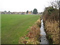
Salt Hill Stream
Viewed looking upstream along the eastern edge of Godolphin Recreation Ground.
Image: © Nigel Cox
Taken: 8 Jan 2009
0.25 miles