IMAGES TAKEN NEAR TO
Seymour Road, SLOUGH, SL1 2NT
Introduction
This page details the photographs taken nearby to Seymour Road, SL1 2NT by members of the Geograph project.
The Geograph project started in 2005 with the aim of publishing, organising and preserving representative images for every square kilometre of Great Britain, Ireland and the Isle of Man.

There are currently over 7.5m images from over14,400 individuals and you can help contribute to the project by visiting https://www.geograph.org.uk
Image Map
Images are licensed for reuse under creativecommons.org/licenses/by-sa/2.0
Notes
- Clicking on the map will re-center to the selected point.
- The higher the marker number, the further away the image location is from the centre of the postcode.
Image Listing (65 Images Found)
Images are licensed for reuse under creativecommons.org/licenses/by-sa/2.0
Image
Details
Distance
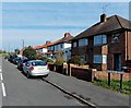
1
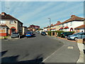
Seymour Road, Slough
A view WSW looking towards the Copthorne Hotel. http://www.geograph.org.uk/photo/3435516
Image: © Jaggery
Taken: 28 Apr 2013
0.03 miles
2
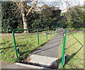
Ramp leading to a stream footbridge, Slough
The footbridge crosses this http://www.geograph.org.uk/photo/3436295 stream. On the far side of the footbridge is Seymour Road.
Image: © Jaggery
Taken: 28 Apr 2013
0.06 miles
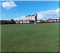
3
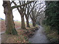
Salt Hill Stream in Montem Recreation Ground in Slough
All the old Ordnance Survey 6" to the mile maps from 1900 through to 1938 show the stream in use in this area for watercress beds, fed by three springs on the bank to the left.
Image: © Nigel Cox
Taken: 8 Jan 2009
0.06 miles
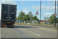
4

Tuns Lane, Chalvey
Heading for Windsor across the Thames beyond.
Image: © David Howard
Taken: 8 Mar 2015
0.07 miles
5
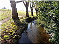
Stream on the west side of Montem Recreation Ground, Slough
Viewed from a footbridge to Seymour Road.
Image: © Jaggery
Taken: 28 Apr 2013
0.07 miles
6
Bourne Road, Slough
A view west from the corner of Seymour Road.
Image: © Jaggery
Taken: 28 Apr 2013
0.07 miles
8

Tuns Lane houses, Slough
The name Tuns Lane has survived long after this dual-carriageway section of the A355 ceased being only a lane. Viewed from near the Beckwell Road junction.
Image: © Jaggery
Taken: 28 Apr 2013
0.10 miles
9
Chalvey Recreation Ground, Slough
Viewed from the SE corner looking towards a Holiday Inn. http://www.geograph.org.uk/photo/3434528
Among the recreation ground regulations are Please clean up after your dog, and no horses, no motorcycles, no playing golf, no fires.
Image: © Jaggery
Taken: 27 Apr 2013
0.12 miles
10
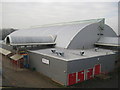
Slough Ice Arena
One of Slough Community Leisure's venues, the latest attractions at the arena http://www.sloughleisure.com/sia/index.html are foamtastic evenings and ice karting. The arena is also the home of Slough Jets http://www.sloughjets.co.uk/ ice hockey team who play in the English Premier Ice Hockey League. This view was taken from the top of Image
Image: © Nigel Cox
Taken: 8 Jan 2009
0.12 miles