IMAGES TAKEN NEAR TO
Ford Lane, IVER, SL0 9LL
Introduction
This page details the photographs taken nearby to Ford Lane, SL0 9LL by members of the Geograph project.
The Geograph project started in 2005 with the aim of publishing, organising and preserving representative images for every square kilometre of Great Britain, Ireland and the Isle of Man.

There are currently over 7.5m images from over14,400 individuals and you can help contribute to the project by visiting https://www.geograph.org.uk
Image Map (Loading...)


Getting Data...Please wait
Leaflet Map data © OpenStreetMap
Images are licensed for reuse under creativecommons.org/licenses/by-sa/2.0
Notes
- Clicking on the map will re-center to the selected point.
- The higher the marker number, the further away the image location is from the centre of the postcode.
Image Listing (110 Images Found)
Images are licensed for reuse under creativecommons.org/licenses/by-sa/2.0
Image
Details
Distance
1
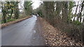
Ford Lane, Iver. (2)
Half way down Ford Lane, Huntsmoor Park Farm on left, and Farlows Lake on the right.
Image: © Rob Emms
Taken: 9 Dec 2016
0.09 miles
3
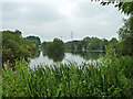
Farlows Lake
The full extent of this large lake cannot be seen because of the numerous islands. It was formerly gravel workings, now used for fishing.
Image: © Robin Webster
Taken: 21 Jul 2013
0.10 miles
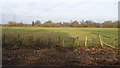
4
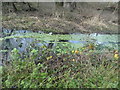
Former Huntsmoor Park land
The earthwork, part of a formation extending to the River Colne, is a bit of a mystery, apparently not part of the original parkland. It does not appear on maps or aerial views until the last few years. It is contemporary with a concrete chambered fish farm where the caravans are, but seemingly unconnected with it.
Image: © Robin Webster
Taken: 21 Jul 2013
0.11 miles
5

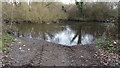
Ford Lane, Iver. (3)
End of the road, any further and it's the River Colne.
Image: © Rob Emms
Taken: 9 Dec 2016
0.12 miles
6
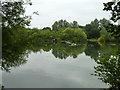
Farlows Lake
This large lake, formerly gravel workings, is now used for fishing.
Image: © Robin Webster
Taken: 21 Jul 2013
0.12 miles
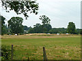
7
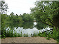
Part of Farlows Lake
A comparatively small corner of the large lake, formerly gravel workings, now used for fishing.
Image: © Robin Webster
Taken: 21 Jul 2013
0.13 miles
9
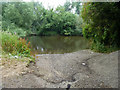
Ford on Ford Lane
A former crossing of the River Colne to Packet Boat Lane. The other bank is in fact a narrow island, it seems the crossing made its way across it to then ford the other river branch.
Image: © Robin Webster
Taken: 21 Jul 2013
0.13 miles
10
Ford Lane meets the River Colne
This is an old ford crossing, and it's a good 50 metres across to the other bank, which is in Greater London. The river has been dug deeper too stop vehicles trying to cross. Just visible, to the right, the river can be seen to be very shallow.
Image: © Rob Emms
Taken: 9 Dec 2016
0.13 miles