IMAGES TAKEN NEAR TO
Swan Road, IVER, SL0 9LB
Introduction
This page details the photographs taken nearby to Swan Road, SL0 9LB by members of the Geograph project.
The Geograph project started in 2005 with the aim of publishing, organising and preserving representative images for every square kilometre of Great Britain, Ireland and the Isle of Man.

There are currently over 7.5m images from over14,400 individuals and you can help contribute to the project by visiting https://www.geograph.org.uk
Image Map
Images are licensed for reuse under creativecommons.org/licenses/by-sa/2.0
Notes
- Clicking on the map will re-center to the selected point.
- The higher the marker number, the further away the image location is from the centre of the postcode.
Image Listing (16 Images Found)
Images are licensed for reuse under creativecommons.org/licenses/by-sa/2.0
Image
Details
Distance
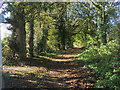
1
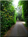
Beeches Way (84)
The route goes south on Swan Road.
Image: © Shazz
Taken: 21 May 2013
0.05 miles
2
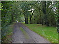
Swan Road
The access road that runs from Swan Road to Lower Delaford.
Image: © Alan Hunt
Taken: 13 Oct 2012
0.05 miles
3
Coppins Lane, Iver
An access road to Coppins Farm from Bangor Road South.
Image: © Alan Hunt
Taken: 13 Oct 2012
0.13 miles
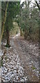
4
Beeches Way (83)
The path follows the field edge.
Image: © Shazz
Taken: 21 May 2013
0.14 miles
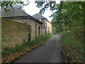
5
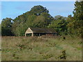
Coppins Farm
One of the outhouses of this derelict farm near Iver.
Image: © Alan Hunt
Taken: 13 Oct 2012
0.14 miles
6
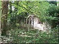
Iver: Overgrown remains of abandoned bungalow
Image: © Rob Emms
Taken: 24 Aug 2017
0.15 miles
7
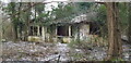
Coppins Farm Cottage
Neglected old cottage
Image: © John Chisholm
Taken: 8 Feb 2021
0.15 miles
8
The Beeches Way
The track known as The Beeches Way near Coppins Farm in Iver.
Image: © Alan Hunt
Taken: 13 Oct 2012
0.16 miles
9
Beeches Way
Beeches Way heading to Coppins Lane
Image: © Shaun Ferguson
Taken: 30 Oct 2012
0.16 miles
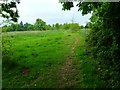
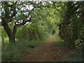
10
Footpath at end of Coppins lane
Heading east towards Palmers Moor
Image: © John Chisholm
Taken: 8 Feb 2021
0.16 miles