IMAGES TAKEN NEAR TO
Dodge Hill, STOCKPORT, SK4 1RD
Introduction
This page details the photographs taken nearby to Dodge Hill, SK4 1RD by members of the Geograph project.
The Geograph project started in 2005 with the aim of publishing, organising and preserving representative images for every square kilometre of Great Britain, Ireland and the Isle of Man.

There are currently over 7.5m images from over14,400 individuals and you can help contribute to the project by visiting https://www.geograph.org.uk
Image Map
Images are licensed for reuse under creativecommons.org/licenses/by-sa/2.0
Notes
- Clicking on the map will re-center to the selected point.
- The higher the marker number, the further away the image location is from the centre of the postcode.
Image Listing (841 Images Found)
Images are licensed for reuse under creativecommons.org/licenses/by-sa/2.0
Image
Details
Distance
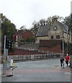
1
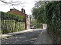
Stockport - Dodge Hill
A conservation area close to the M60, but - contrary to the OS 1:50k map - not connected to Lancashire Hill.
Image: © Peter Whatley
Taken: 1 Apr 2009
0.01 miles
2
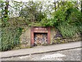
On Dodge Hill
I first thought that this was an old air-raid shelter. There certainly is an old air-raid shelter on Dodge Hill but according to an archived document http://web.archive.org/web/20150624115924/http://www.stockport.gov.uk:80/2013/2978/8803/9020/12299/dodgehillapp1 (see page 4), this was a man-made cavern used until the early part of the 19th century as a smithy.
Image: © Gerald England
Taken: 14 Apr 2011
0.01 miles
3
Heaton Norris - nursing home at top of Dodge Hill
For an alternative view, please see Image
Image: © Dave Bevis
Taken: 7 Aug 2013
0.02 miles
4
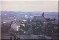
Stockport, August 1960
This photograph was taken from the tower of Pendlebury Hall, on Dodge Hill, north of the town centre.
On the right, spanning the valley of the river Mersey is the brick built railway viaduct of 27 arches,
and the splendid town hall clock tower stands out above the horizon near the left hand edge of the picture.
Image: © Geoff Royle
Taken: Unknown
0.02 miles
5
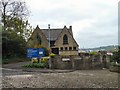
Christadelphian Meeting House
The Stockport Christadelphian Meeting House on Dodge Hill. The building was erected as a high school in 1857 by Major Coppock, a Unitarian who objected to the religious teaching at Stockport Grammar School. The first Christadelphian meeting was held in 1875, and it was subsequently taken over as a synagogue in 1895. In 1902 the Christadelphians took it over again and continue to use it today.
Image: © Gerald England
Taken: 14 Apr 2011
0.02 miles
6
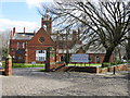
Grosvenor Hall Nursing Home
Near the top of Dodge Hill, Stockport.
Image: © Peter Whatley
Taken: 1 Apr 2009
0.03 miles
7
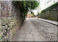
Dodge Hill
Steep cobbled street to the North of Stockport.
Image: © Gerald England
Taken: 14 Apr 2011
0.03 miles
8
Dodge Hill
Christadelphian Meeting Rooms on the corner of Dodge Hill and Lancashire Hill.
Image: © Gerald England
Taken: 28 Oct 2008
0.03 miles
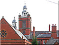
9
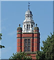
Detail of Pendlebury Hall, Heaton Norris
The tower, complete with domed cupola (1880-82, by J.W. Beaumont).
Image: © Stephen Richards
Taken: 18 Aug 2016
0.03 miles
10
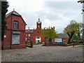
Grosvenor Hall
Care home on Dodge Hill. This was originally Pendlebury Hall, an orphanage designed by architect J.W. Beaumont and erected 1881-2. It was founded through the bequest of Ralph Pendlebury who left £100,000 for the purpose. Pendlebury started his working life as apprentice to a handloom weaver, but later built and owned mills in Stockport.
Image: © Gerald England
Taken: 14 Apr 2011
0.03 miles