IMAGES TAKEN NEAR TO
Western Lane, HIGH PEAK, SK23 7NS
Introduction
This page details the photographs taken nearby to Western Lane, SK23 7NS by members of the Geograph project.
The Geograph project started in 2005 with the aim of publishing, organising and preserving representative images for every square kilometre of Great Britain, Ireland and the Isle of Man.

There are currently over 7.5m images from over14,400 individuals and you can help contribute to the project by visiting https://www.geograph.org.uk
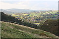
Image Map
Images are licensed for reuse under creativecommons.org/licenses/by-sa/2.0
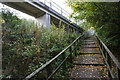
Notes
- Clicking on the map will re-center to the selected point.
- The higher the marker number, the further away the image location is from the centre of the postcode.
Image Listing (125 Images Found)
Images are licensed for reuse under creativecommons.org/licenses/by-sa/2.0
Image
Details
Distance
1
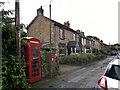
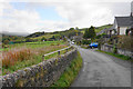
Buxworth, main street
The canal basin at the head of the Peak Forest Canal is called Bugsworth. The village is called Buxworth.
Whatever the name, the cricket ground users are obviously bugging the residents in the terrace opposite. All have wire mesh protection across their front windows.
Image: © Chris Morgan
Taken: 10 Sep 2012
0.02 miles
2
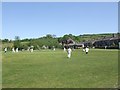
Cricket Ground at Buxworth
A fine day for a cricket match on a sloping field.
Image: © John M
Taken: 26 May 2012
0.03 miles
3
Buxworth
Beyond the village (from left), Chinley Churn and Cracken Edge Image, The Naze Image, South Head Image, Brown Knoll Image Taken from the footpath to Hilltop (south of the village) looking northeast.
Image: © Dave Dunford
Taken: 9 Oct 2005
0.04 miles
4
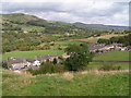
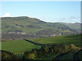
Fields above Buxworth
The hamlet nestles in the bottom of the valley with Chinley Churn rising behind.
Image: © Bill Boaden
Taken: 17 Oct 2015
0.07 miles
5
Buxworth from the slopes of Eccles Pike
From the footpath between Buxworth and Hilltop. Mellor Moor (Image) in the distance.
Image: © Dave Dunford
Taken: 2 Oct 2014
0.08 miles
6
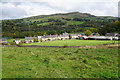
Western Lane, Buxworth
The main road in the southern half of the village, now defined as south of the bypass.
Image: © Bill Boaden
Taken: 17 Oct 2015
0.08 miles
7
Overlooking Buxworth
Bugsworth, Buxworth, which do you prefer?
According to Wiki, the town had its name changed to the posher version in 1930, supported by a majority of the villagers, with the encouragement of the vicar and head-teacher. It is referred to by locals today as "Buggy".
Image: © Peter Barr
Taken: 19 Nov 2010
0.10 miles
8
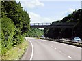
Footbridge over the A6 at Buxworth
The Chapel-en-le-Frith /Whaley Bridge section of the A6 was bypassed in the 80s, with this four-mile long good dual carriageway which twists up the valley.
Image: © David Dixon
Taken: 4 Aug 2014
0.11 miles
9

Footbridge over A6
The A6 between Whaley Bridge and Chapel-en-le-Frith is one of the few stretches for miles in either direction that is dual-carriageway - a relief to motorists but something of a blight on the local settlements. This footbridge, carrying a footpath linking Bugsworth Basin with the southern half of Buxworth village, is right on the grid-square boundary.
Image: © Dave Dunford
Taken: 2 Oct 2014
0.11 miles
10
Path across the A6
The path has to climb so that it can cross the dual carriageway by a footbridge.
Image: © Bill Boaden
Taken: 17 Oct 2015
0.12 miles