IMAGES TAKEN NEAR TO
Tunstead Milton, Whaley Bridge, HIGH PEAK, SK23 7GL
Introduction
This page details the photographs taken nearby to SK23 7GL by members of the Geograph project.
The Geograph project started in 2005 with the aim of publishing, organising and preserving representative images for every square kilometre of Great Britain, Ireland and the Isle of Man.

There are currently over 7.5m images from over14,400 individuals and you can help contribute to the project by visiting https://www.geograph.org.uk
Image Map
Images are licensed for reuse under creativecommons.org/licenses/by-sa/2.0
Notes
- Clicking on the map will re-center to the selected point.
- The higher the marker number, the further away the image location is from the centre of the postcode.
Image Listing (28 Images Found)
Images are licensed for reuse under creativecommons.org/licenses/by-sa/2.0
Image
Details
Distance
1
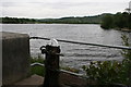
Footpath by Combs Reservoir
The path crosses a potential outflow into Meveril Brook, so I imagine you cannot use the path when the reservoir is full.
Image: © Bill Boaden
Taken: 20 Apr 2022
0.01 miles
3
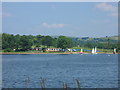
Combs Reservoir
Pronounced to rhyme with 'tombs', the reservoir was built to supply water to the Peak Forest Canal. It is now also used for sailing and fishing.
Image: © Graham Hogg
Taken: 17 Jun 2013
0.04 miles
4
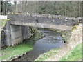
Road bridge over spillway below Combs Reservoir
Image: © Dr Duncan Pepper
Taken: 1 Apr 2010
0.05 miles
5
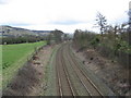
The railway line to Chapel-en-le-Frith
Image: © Dr Duncan Pepper
Taken: 1 Apr 2010
0.06 miles
6
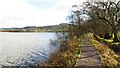
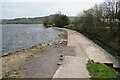
Path along south western side of Combs Reservoir
This section of the path has recently been improved but further along this path it is very muddy due to heavy footfall.
Image: © Colin Park
Taken: 27 Jan 2022
0.10 miles
7
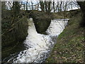
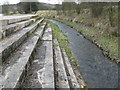
Two spillways join below Combs Reservoir
Image: © Dr Duncan Pepper
Taken: 1 Apr 2010
0.13 miles
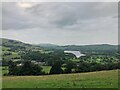
9

View over Combs Reservoir
The reservoir was built in 1794 as a feeder for the Peak Forest Canal which terminates in nearby Whaley Bridge
Image: © Graham Hogg
Taken: 15 Sep 2017
0.13 miles