IMAGES TAKEN NEAR TO
Reservoir Road, HIGH PEAK, SK23 7BL
Introduction
This page details the photographs taken nearby to Reservoir Road, SK23 7BL by members of the Geograph project.
The Geograph project started in 2005 with the aim of publishing, organising and preserving representative images for every square kilometre of Great Britain, Ireland and the Isle of Man.

There are currently over 7.5m images from over14,400 individuals and you can help contribute to the project by visiting https://www.geograph.org.uk
Image Map
Images are licensed for reuse under creativecommons.org/licenses/by-sa/2.0
Notes
- Clicking on the map will re-center to the selected point.
- The higher the marker number, the further away the image location is from the centre of the postcode.
Image Listing (175 Images Found)
Images are licensed for reuse under creativecommons.org/licenses/by-sa/2.0
Image
Details
Distance
1
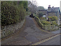
Cow Lane Whaley Bridge
A footpath connecting Reservoir Road and Orchard Road. The original footpath was setted but has now been covered in macadam. However, the original stone setts can still be seen at the bottom of the path on Reservoir Road and along the right hand edge of the footpath.
Image: © Bob Prophet
Taken: 11 Nov 2011
0.02 miles
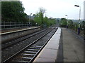
2
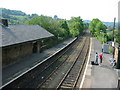
Whaley Bridge Railway Station
Looking South towards Buxton
Image: © BB
Taken: 30 May 2003
0.08 miles
3
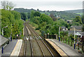
Railway at Whaley Bridge, Derbyshire
From the footbridge, looking south towards Buxton.
Image: © Roger D Kidd
Taken: 6 Sep 2014
0.09 miles
4
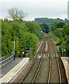
Railway at Whaley Bridge, Derbyshire
From the station footbridge, looking south towards Buxton.
Image: © Roger D Kidd
Taken: 6 Sep 2014
0.09 miles
5
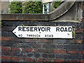
Road to Toddbrook Reservoir
On the corner of Whaley Lane and Reservoir Road. Old style road sign with "No through road" warning.
Image: © Mr Red
Taken: 25 Jun 2021
0.09 miles
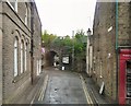
6
On Reservoir Road, Whaley Bridge
Close to Whaley Bridge Railway Station
Image: © Neil Theasby
Taken: 4 Jun 2015
0.09 miles
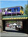
7
Wharf Road
Leading under the railway bridge to wharves by the canal.
Image: © Gerald England
Taken: 20 May 2011
0.10 miles
8
Railway towards Buxton
Looking south from Whaley Bridge Railway Station.
Image: © JThomas
Taken: 24 May 2014
0.11 miles
9
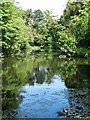
Brookfield Pond, Whaley Bridge
Now a nature reserve but it was first constructed to serve local industry.
Image: © Neil Theasby
Taken: 4 Jun 2015
0.11 miles
10
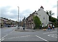
The Railway, Whaley Bridge
The pub on Market Street (A5004) is currently owned by Inglenook Inns & Taverns.
Image
Image: © Gerald England
Taken: 27 Aug 2021
0.11 miles