IMAGES TAKEN NEAR TO
Mayflower Close, HIGH PEAK, SK23 0UG
Introduction
This page details the photographs taken nearby to Mayflower Close, SK23 0UG by members of the Geograph project.
The Geograph project started in 2005 with the aim of publishing, organising and preserving representative images for every square kilometre of Great Britain, Ireland and the Isle of Man.

There are currently over 7.5m images from over14,400 individuals and you can help contribute to the project by visiting https://www.geograph.org.uk
Image Map (Loading...)


Getting Data...Please wait
Leaflet Map data © OpenStreetMap
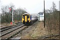
Images are licensed for reuse under creativecommons.org/licenses/by-sa/2.0
Notes
- Clicking on the map will re-center to the selected point.
- The higher the marker number, the further away the image location is from the centre of the postcode.
Image Listing (31 Images Found)
Images are licensed for reuse under creativecommons.org/licenses/by-sa/2.0
Image
Details
Distance
1
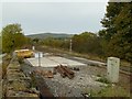
Maintenance access to the railway
A working platform has been established where there is easy road access to allow maintenance vehicles to be transferred onto the railway. This is the former Midland Railway main line from London to Manchester but is now used exclusively for freight trains from the quarries in the Buxton area.
Image: © Alan Murray-Rust
Taken: 25 Oct 2015
0.09 miles
2
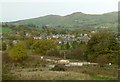
View from Chapel-en-le-Frith station approach
Looking across the town towards Mount Famine (centre left) and South Head (centre right). In the foreground is the former Midland Railway main line, now exclusively a freight line.
Image: © Alan Murray-Rust
Taken: 25 Oct 2015
0.11 miles
3
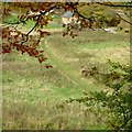
Footpath to the station
Chapel-en-le-Frith railway station is well outside the town, and it is clear that a substantial number of passengers make their way to it using this footpath.
Image: © Alan Murray-Rust
Taken: 25 Oct 2015
0.13 miles
4
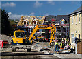
Chapel-en-le-Frith
New housing development at Chapel-en-le-Frith.
Image: © Peter McDermott
Taken: 26 Apr 2015
0.14 miles
5
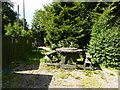
Recycled picnic table
At Chapel-en-le-Frith station a bench from a surplus cable reel.
Image: © Peter Barr
Taken: 31 Aug 2010
0.18 miles
6
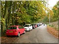
Station approach, Chapel
Used as an overflow car park. The station is clearly well used even on a Sunday.
Image: © Alan Murray-Rust
Taken: 25 Oct 2015
0.18 miles
7
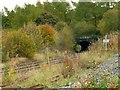
Railway tunnel near Chapel-en-le-Frith
This carries the former Midland Railway main line under the London and North Western Railways line to Buxton.
Image: © Alan Murray-Rust
Taken: 25 Oct 2015
0.19 miles
8
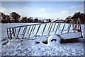
Hay cart on the path to Chapel station
The path that cuts across the fields to Chapel-en-le-Frith Station in winter.
Image: © ron layters
Taken: 3 Feb 2009
0.19 miles
9
Chapel en le Frith Station
A service from Buxton passes the signal box and arrives at the station.
Image: © roger geach
Taken: 20 Mar 2010
0.19 miles
10
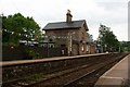
Chapel-en-le-Frith railway station
The bunting is to celebrate the 150th anniversary of the opening of the station. Chapel-en-le-Frith is the home of Ferodo. (I'm not sure where Berilbo lives!)
Image: © Graham Hogg
Taken: 17 Jun 2013
0.20 miles