IMAGES TAKEN NEAR TO
Rowarth, HIGH PEAK, SK22 1DX
Introduction
This page details the photographs taken nearby to SK22 1DX by members of the Geograph project.
The Geograph project started in 2005 with the aim of publishing, organising and preserving representative images for every square kilometre of Great Britain, Ireland and the Isle of Man.

There are currently over 7.5m images from over14,400 individuals and you can help contribute to the project by visiting https://www.geograph.org.uk
Image Map
Images are licensed for reuse under creativecommons.org/licenses/by-sa/2.0
Notes
- Clicking on the map will re-center to the selected point.
- The higher the marker number, the further away the image location is from the centre of the postcode.
Image Listing (4 Images Found)
Images are licensed for reuse under creativecommons.org/licenses/by-sa/2.0
Image
Details
Distance
1
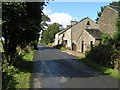
The Inns at Rowarth
A 17th-century former coaching inn, in 1926 this building was named The Children's Inn and was used to provide country holidays for children from Manchester; in 1933 the complex was taken over by the Guide Association, who now run it as an Outdoor Activities Centre. See http://www.theinnsatrowarth.org.uk . The Mass Trespass on Kinder Scout (see Image) was planned here at Easter 1932.
Image: © Dave Dunford
Taken: 25 Sep 2005
0.12 miles
2
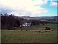
Overlooking the Inns at Rowarth
Former 17th Century Coaching Inn, now The Children's Inn and maintained by the Stockport Girl Guides Association for short breaks and activities.
Image: © Jonathan Clitheroe
Taken: 18 Feb 2012
0.16 miles
3
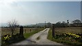
Springs Knoll
Farmhouse off Hollinsmoor Road. Countryside between New Mills, to the south, and Charleswort to the north.
Image: © Peter Barr
Taken: 28 Mar 2011
0.20 miles