IMAGES TAKEN NEAR TO
Mansfield Road, HYDE, SK14 5PG
Introduction
This page details the photographs taken nearby to Mansfield Road, SK14 5PG by members of the Geograph project.
The Geograph project started in 2005 with the aim of publishing, organising and preserving representative images for every square kilometre of Great Britain, Ireland and the Isle of Man.

There are currently over 7.5m images from over14,400 individuals and you can help contribute to the project by visiting https://www.geograph.org.uk
Image Map
Images are licensed for reuse under creativecommons.org/licenses/by-sa/2.0
Notes
- Clicking on the map will re-center to the selected point.
- The higher the marker number, the further away the image location is from the centre of the postcode.
Image Listing (330 Images Found)
Images are licensed for reuse under creativecommons.org/licenses/by-sa/2.0
Image
Details
Distance
1

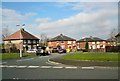
The End of Grange Road North
Grange Road North ends here. Beyond is a huge drop into the cutting through which ran the Godley to Apethorn railway. The track is long gone and the route is now a section of the Trans Pennine Trail. A footpath on the left gives access to the trail and another leads to the footbridge over to Grange Road South Image
Image: © Gerald England
Taken: 23 Aug 2010
0.04 miles
2
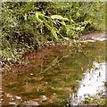
Reflections in a puddle on the Trans Pennine Trail
Rain had turned the section used by horse-riders into a muddy quagmire.
Image: © Gerald England
Taken: 3 Aug 2015
0.04 miles
3

Top end of Grange Road North
The cobbled path in the centre leads to Bridge #126 Image over the former railway line from Godley Junction to Apethorn. The footbridge connects to the bottom of Grange Road South. On the right a footpath zig-zags down the embankment on to the former trackbed which is now utilised by the Trans Pennine Trail and National Cycle Network Route #62.
Image: © Gerald England
Taken: 2 May 2020
0.04 miles
4
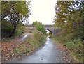
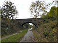
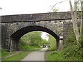
Bridge #126
Bridge #126 takes a footpath that connects Grange Road North to Grange Road South over the former railway line from Godley Junction to Apethorn. The "Cheshire Lines Committee (CLC)" route opened in 1866. Following the electrification of the Woodhead line in 1954 and until 1981 when the through route to Sheffield closed, the main traffic on the line consisted of trains from the Yorkshire coalfield to the Fiddlers Ferry power station. Most of the former trackbed is now utilised by the Trans Pennine Trail and National Cycle Network Route #62
Image: © Gerald England
Taken: 4 Nov 2016
0.04 miles
5

Grange Road Footbridge
Bridge over the former Godley to Apethorn Railway (now Trans Pennine Trail) connecting Grange Road South Image to Grange Road North. The view is from the footpath giving access from Grange Road North to the trail.
Image: © Gerald England
Taken: 23 Aug 2010
0.05 miles
6
Bridge #126
The bridge over the former Godley Junction to Apethorn Railway line, now utilised by the Trans Pennine Trail and National Cycle Network #62, connects Grange Road South with Grange Road North but only for pedestrians.
Image: © Gerald England
Taken: 19 Oct 2014
0.05 miles
7
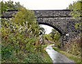
Bridge #126
Bridge #126 takes a footpath that connects Grange Road North to Grange Road South over the former railway line from Godley Junction to Apethorn. The "Cheshire Lines Committee (CLC)" route opened in 1866. Following the electrification of the Woodhead line in 1954 and until 1981 when the through route to Sheffield closed, the main traffic on the line consisted of trains from the Yorkshire coalfield to the Fiddlers Ferry power station. Most of the former trackbed is now utilised by the Trans Pennine Trail and National Cycle Network Route #62
Image: © Gerald England
Taken: 19 Apr 2020
0.05 miles
9
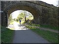
Bridge #125
The bridge over the former Godley Junction to Apethorn Railway line, now utilised by the Trans Pennine Trail and National Cycle Network #62, connects Peel Street with Mansfield Road.
Image: © Gerald England
Taken: 19 Oct 2014
0.06 miles
10
Bridge #125
Bridge #125 is a footbridge connecting Peel Street with Mansfield Road over the former railway line from Godley Junction to Apethorn. The "Cheshire Lines Committee (CLC)" route opened in 1866. Following the electrification of the Woodhead line in 1954 and until 1981 when the through route to Sheffield closed, the main traffic on the line consisted of trains from the Yorkshire coalfield to the Fiddlers Ferry power station. Most of the former trackbed is now utilised by the Trans Pennine Trail and National Cycle Network Route #62
Image: © Gerald England
Taken: 2 May 2020
0.06 miles