IMAGES TAKEN NEAR TO
Waverley Road, HYDE, SK14 5AX
Introduction
This page details the photographs taken nearby to Waverley Road, SK14 5AX by members of the Geograph project.
The Geograph project started in 2005 with the aim of publishing, organising and preserving representative images for every square kilometre of Great Britain, Ireland and the Isle of Man.

There are currently over 7.5m images from over14,400 individuals and you can help contribute to the project by visiting https://www.geograph.org.uk
Image Map
Images are licensed for reuse under creativecommons.org/licenses/by-sa/2.0
Notes
- Clicking on the map will re-center to the selected point.
- The higher the marker number, the further away the image location is from the centre of the postcode.
Image Listing (1053 Images Found)
Images are licensed for reuse under creativecommons.org/licenses/by-sa/2.0
Image
Details
Distance

2
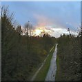
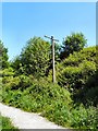
Trans Pennine Trail
Viewed from Dowson Road bridge. The former line from Godley to Apethorn is now a section of the Trans Pennine Trail with separate paths for horseriders and cyclists/walkers.
Image: © Gerald England
Taken: 14 Nov 2009
0.03 miles
3

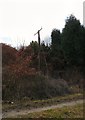
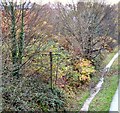
Lost in the Trees
Unlike the one a little further down the line Image this old telegraph post on the former Godley to Apethorn railway line is now almost completely engulfed by trees.
Image: © Gerald England
Taken: 12 Jun 2009
0.03 miles
5
Old telegraph post
An old telegraph post is one of the few trackside remnants of the former Godley Junction to Apethorn railway line, now part of the Trans Pennine Trail and National Cycle Route #62. Taken just after midday on New Year's Day 2013.
Image: © Gerald England
Taken: 1 Jan 2013
0.03 miles
6
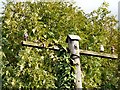
Top of an old telegraph post
A closer view of the old telegraph post Image on the former Godley Junction to Apethorn railway line.
Image: © Gerald England
Taken: 13 Oct 2009
0.03 miles
7
Old telegraph post
This telegraph post is one of the few original bits of railway infrastructure remaining on the former Godley to Apethorn railway line.
Image: © Gerald England
Taken: 31 May 2009
0.03 miles
8
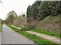
Old telegraph post
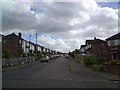
Alongside the former Godley to Apethorn Railway. The view is from Dowson Road bridge Image In the background are houses on Waverley Road. In June 2009 the telegraph post, as viewed from the trail was almost engulfed in foliage Image
Image: © Gerald England
Taken: 14 Nov 2009
0.04 miles
9
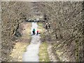
Users of the Trans Pennine Trail
A view from Knott Fold bridge looking towards Dowson Road. The former Godley Junction to Apethorn railway line is now used by the Trans Pennine Trail and the National Cycle Network Route 62. Horse-riders can be seen on the right here and cyclists and dog walkers on the left.
Image: © Gerald England
Taken: 17 Mar 2013
0.04 miles
10
Fallen Tree on Trans Pennine Trail
A tree has fallen (or been deliberately toppled) down the embankment of the former Godley Junction to Apethorn Railway line. The line is now part of the Trans Pennine Trail with separate tracks for walkers/cyclists and horse-riders. The tree is blocking the bridlepath. In the background is the Dowson Road bridge.
Image: © Gerald England
Taken: 3 May 2012
0.04 miles