IMAGES TAKEN NEAR TO
Foxholes Road, HYDE, SK14 5AW
Introduction
This page details the photographs taken nearby to Foxholes Road, SK14 5AW by members of the Geograph project.
The Geograph project started in 2005 with the aim of publishing, organising and preserving representative images for every square kilometre of Great Britain, Ireland and the Isle of Man.

There are currently over 7.5m images from over14,400 individuals and you can help contribute to the project by visiting https://www.geograph.org.uk
Image Map
Images are licensed for reuse under creativecommons.org/licenses/by-sa/2.0
Notes
- Clicking on the map will re-center to the selected point.
- The higher the marker number, the further away the image location is from the centre of the postcode.
Image Listing (278 Images Found)
Images are licensed for reuse under creativecommons.org/licenses/by-sa/2.0
Image
Details
Distance
1
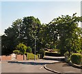
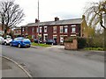
Foxholes Road
Past Grosvenor Crescent, Foxholes Road divides into two going either side of Danny Wood to Thistley Fields.
Image: © Gerald England
Taken: 16 Jun 2010
0.07 miles
2
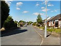
Foxholes Road
The Eastern section of Foxholes Road between Thistley Fields and Grosvenor Crescent.
Image: © Gerald England
Taken: 16 Jun 2010
0.08 miles
3
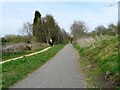
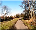
Trans Pennine Trail
The Trans Pennine Trail and National Cycle Network Route #62 follows the route of the former Godley Junction to Apethorn Railway. Cyclists and walkers share the path on the right, whilst horse-riders are supposed to follow a bridle-path to the side. At various points the bridle-path swaps sides.
Image: © Gerald England
Taken: 24 Apr 2010
0.08 miles
4
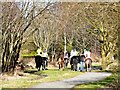
Horses on the Trail
Eight horses on the Trans Pennine Trail.
Image: © Gerald England
Taken: 19 Feb 2012
0.09 miles
5
Thistley Fields
A group of once isolated terraced cottages near the bottom of Apethorn Lane. The nearby fields have been built on by the Foxholes housing estate. Sometimes referred to as Ciceley Fields.
Image: © Gerald England
Taken: 21 Apr 2013
0.09 miles
6
Trans Pennine Trail
The Trans Pennine Trail and National Cycle Network Route #62 on the line of the former Godley Junction to Apethorn railway line. Up ahead are a group of horse-riders.
Image: © Gerald England
Taken: 19 Feb 2012
0.09 miles
7
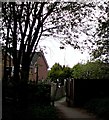
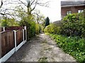
Access to Foxholes Road
From the Trans Pennine Trail.
Image: © Gerald England
Taken: 26 Apr 2020
0.09 miles
8
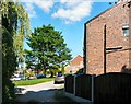
Thistley Fields
A row of old terraced houses now fronted by the modern estate around Foxholes Road.
Image: © Gerald England
Taken: 16 Jun 2010
0.10 miles
10
Thistley Fields
Footpath past Thistley Fields to Foxholes Road.
Image: © Gerald England
Taken: 24 Apr 2010
0.11 miles