IMAGES TAKEN NEAR TO
SK14 3NB
Introduction
This page details the photographs taken nearby to SK14 3NB by members of the Geograph project.
The Geograph project started in 2005 with the aim of publishing, organising and preserving representative images for every square kilometre of Great Britain, Ireland and the Isle of Man.

There are currently over 7.5m images from over14,400 individuals and you can help contribute to the project by visiting https://www.geograph.org.uk
Image Map
Images are licensed for reuse under creativecommons.org/licenses/by-sa/2.0
Notes
- Clicking on the map will re-center to the selected point.
- The higher the marker number, the further away the image location is from the centre of the postcode.
Image Listing (90 Images Found)
Images are licensed for reuse under creativecommons.org/licenses/by-sa/2.0
Image
Details
Distance
1
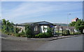
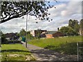
Hattersley Baptist Church
The last remaining highrise block in Hattersley is visible behind.
Image: © Bill Boaden
Taken: 22 Jun 2010
0.03 miles
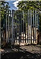
3
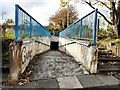
Hattersley Underpass
An underpass from Chain Bar Lane leading under Stockport Road.
Image: © Gerald England
Taken: 21 Oct 2010
0.05 miles
4
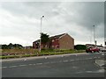
Awaiting Possible Demolition
A large part of the Hattersley Estate has recently been demolished. It was originally an overspill area for Manchester. These houses on Shelmardine Close, facing Stockport Road and viewed here from Ashworth Lane are the last remaining in this section.
Update: One of these houses is privately owned and the owner refused all offers to sell and so they have survived.
Image: © Gerald England
Taken: 20 Aug 2008
0.08 miles
5
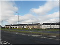
St James' Roman Catholic Primary School
Off Underwood Road, Hattersley.
Image: © Gerald England
Taken: 6 Jun 2011
0.09 miles
6
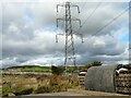
Pylons over Hattersley
Power lines over the top of Hattersley stretching towards Harrop Edge.
Image: © Gerald England
Taken: 21 Oct 2010
0.10 miles
8
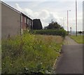
Stockport Road, Hattersley
The A560 at Hattersley from the junction with Ashworth Lane. The council demolished all the houses on the east side of Stockport in the mid-noughties. However one owner resisted all offers to purchase and remains. Wildflowers grow on the former garden of the adjacent boarded-up house.
Image: © Gerald England
Taken: 19 Jun 2014
0.11 miles
9
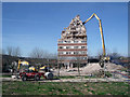
Hattersley multi-storey flats demolition
This tower block is the last building to be demolished in the area that was Hattersley Precinct. When completed in the late 1960s/early 1970s the Four in Hand public house stood to the right of the tower, the red machine stands on the walkway that originally had shops on both sides and the ends, about 25 shops in total selling all sorts of goods even a record shop. Most of the shops were demolished 25/30 years ago the rest following more recently. Close up http://www.geograph.org.uk/photo/5323126
Image: © Stephen Burton
Taken: 24 Mar 2017
0.11 miles
10
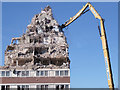
Hattersley multi-storey flats demolition
Powerful machine ripping lumps of reinforced concrete from the last remaining tower block at Hattersley.
Image: © Stephen Burton
Taken: 24 Mar 2017
0.11 miles