IMAGES TAKEN NEAR TO
Mottram Road, HYDE, SK14 2SL
Introduction
This page details the photographs taken nearby to Mottram Road, SK14 2SL by members of the Geograph project.
The Geograph project started in 2005 with the aim of publishing, organising and preserving representative images for every square kilometre of Great Britain, Ireland and the Isle of Man.

There are currently over 7.5m images from over14,400 individuals and you can help contribute to the project by visiting https://www.geograph.org.uk
Image Map
Images are licensed for reuse under creativecommons.org/licenses/by-sa/2.0
Notes
- Clicking on the map will re-center to the selected point.
- The higher the marker number, the further away the image location is from the centre of the postcode.
Image Listing (197 Images Found)
Images are licensed for reuse under creativecommons.org/licenses/by-sa/2.0
Image
Details
Distance
1
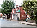
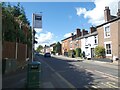
Godley Off Licence & Convenience Store
On the corner of Mottram Road and Leech Street.
Image: © Gerald England
Taken: 31 May 2011
0.03 miles
2
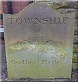
Old Boundary Marker by the A57, Mottram Road, Hyde parish
Parish Boundary Marker by the A57, in parish of Hyde (Tameside District), Mottram Road, against brick wall at back of pavement outside 196 Mottram Road, South side of road.
Inscription reads:-
TOWNSHIP
of
GODLEY | HYDE
Surveyed
Milestone Society National ID: CH_HYDGOD01pb
Image: © Milestone Society
Taken: Unknown
0.04 miles
3
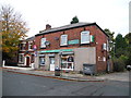
Godley Brook Off Licence and General Store
Mottram Road (A57).
Image: © John Topping
Taken: 30 Oct 2013
0.04 miles
4
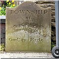
Godley/Hyde Township boundary stone
This boundary stone between the Townships of Godley and Hyde is on Mottram Road. It stands in front of the wall of #186 Mottram Road Image
It is similar to Werneth/Bredbury boundary stone Image and the Hyde/Werneth boundary stone Image
Image: © Gerald England
Taken: 23 Jun 2015
0.04 miles
5
Godley and Hyde Boundary
In front of the wall of #196 Mottram Road almost hidden by a wheelie-bin is the boundary stone Image between the Townships of Godley and Hyde.
Image: © Gerald England
Taken: 23 Jun 2015
0.04 miles
6
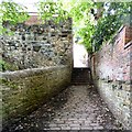
Steps on a footpath
A set of steps on the footpath from Godley leading to Mottram Road.
Image: © Gerald England
Taken: 3 Aug 2015
0.05 miles
7
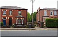
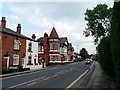
Mottram Road
The A57 towards Hyde.
The fourth house along on the right is the Grade II listed https://historicengland.org.uk/listing/the-list/list-entry/1268420?section=official-list-entry Brookbank House that was built in 1837 by the local Hibbert family. It is now used as a day nursery.
Image: © Gerald England
Taken: 16 Sep 2022
0.06 miles
9
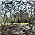
Brookbank Folly Castle
The castellated folly castle overlooking Godley Brook lies in the back garden of Brookbank House. The house was built in 1837 by Joseph Hibbert, the sixth of fourteen children of Randal Hibbert. The Hibbert family of Godley played an important part in the history of Hyde and its neighbourhood, figuring amongst the pioneers of the cotton industry.
The castle folly was probably built around the mid part of the 19th century. In the mid-1990s there were plans by the then owners to restore the building and open it up to the public. http://hydonian.blogspot.co.uk/2011/12/brookbank-house-castle-folly.html
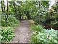
Now it belongs to the Brookbank Day Nursery Image and public access to the folly is not permitted. It can however be viewed from the footpath on the North side of the Godley Brook.
Image: © Gerald England
Taken: 26 Mar 2012
0.06 miles
10
Bankfield Hotel
A57, Mottram Road, Hyde showing the long-closed Bankfield Hotel; compare with Image
Image: © Gerald England
Taken: 13 Sep 2008
0.06 miles