IMAGES TAKEN NEAR TO
Blenheim Close, STOCKPORT, SK12 1DN
Introduction
This page details the photographs taken nearby to Blenheim Close, SK12 1DN by members of the Geograph project.
The Geograph project started in 2005 with the aim of publishing, organising and preserving representative images for every square kilometre of Great Britain, Ireland and the Isle of Man.

There are currently over 7.5m images from over14,400 individuals and you can help contribute to the project by visiting https://www.geograph.org.uk
Image Map
Images are licensed for reuse under creativecommons.org/licenses/by-sa/2.0
Notes
- Clicking on the map will re-center to the selected point.
- The higher the marker number, the further away the image location is from the centre of the postcode.
Image Listing (23 Images Found)
Images are licensed for reuse under creativecommons.org/licenses/by-sa/2.0
Image
Details
Distance
1
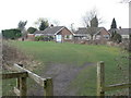
Footpath to Oakfield Road
Crossing the corner of an open space at the eastern end of Poynton.
Image: © Alan Murray-Rust
Taken: 25 Mar 2010
0.07 miles
2

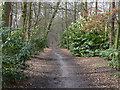
Lady's Incline
The course of the railway to Lord and Lady Pits. The brickwork indicates the location of the wheel pit at the top of the rope-worked incline. This was a self-acting incline, with the weight of loaded trucks running down the incline hauling up returning empties. It was converted to locomotive operation in 1889.
Image: © Alan Murray-Rust
Taken: 25 Mar 2010
0.08 miles
3
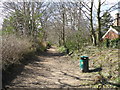
The end of Lady's Incline
This was the railway access to Lord Pit and Lady Pit, originally a rope work incline, but locomotive hauled from about 1889. The section visible here is more or less level and would have been horse drawn rather than rope worked until that time.
Image: © Alan Murray-Rust
Taken: 25 Mar 2010
0.13 miles
4

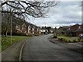
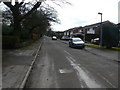
Towers Road
A quiet leafy residential quarter in Poynton.
Image: © Bill Boaden
Taken: 29 Sep 2022
0.16 miles
5
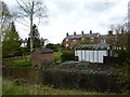
Gardens, sheds and raised beds
Long gardens, with a stream at the bottom,Park Lane.
Image: © Peter Barr
Taken: 24 Apr 2012
0.17 miles
6
Charlecote Road
Modern housing infilling between the former colliery railway inclines. Poynton is essentially a commuter dormitory for Greater Manchester.
Image: © Alan Murray-Rust
Taken: 25 Mar 2010
0.17 miles
7
Towers Road (1)
Looking south from Prince's Incline. The status of the road is not clear on larger scale OS as it carries footpath right of way markings. It is however the main access to a substantial housing development to the right of the picture, and local authority mapping shows that it is in fact an adopted highway up to this point. The road started life as a colliery tramroad taking coal from local collieries to a coal yard on the main turnpike road to Stockport. It would certainly have been constructed privately which doubtless explains the uncertainty.
Image: © Alan Murray-Rust
Taken: 25 Mar 2010
0.18 miles
8
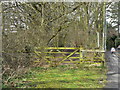
Prince's Incline (1)
This was significantly the longer of the two main inclines on the Poynton Collieries railway system. Originally rope-worked, it was converted to locomotive haulage in 1889. Although worked by the colliery company, it was originally built by the Manchester and Birmingham Railway (one of the constituent companies of the London and North Western Railway, and still part of the main route from Manchester to London) and remains the only part of that Company's network to have closed.
Image: © Alan Murray-Rust
Taken: 25 Mar 2010
0.20 miles
9

Poynton Fire Station
The fire station on School Lane.
Image: © David Dixon
Taken: 12 Nov 2011
0.20 miles
10
Prince's Incline, Poynton
Looking west down the incline, from Towers Road.
Image: © John Topping
Taken: 3 Apr 2013
0.20 miles