IMAGES TAKEN NEAR TO
Spuley Lane, MACCLESFIELD, SK10 5DE
Introduction
This page details the photographs taken nearby to Spuley Lane, SK10 5DE by members of the Geograph project.
The Geograph project started in 2005 with the aim of publishing, organising and preserving representative images for every square kilometre of Great Britain, Ireland and the Isle of Man.

There are currently over 7.5m images from over14,400 individuals and you can help contribute to the project by visiting https://www.geograph.org.uk
Image Map
Images are licensed for reuse under creativecommons.org/licenses/by-sa/2.0
Notes
- Clicking on the map will re-center to the selected point.
- The higher the marker number, the further away the image location is from the centre of the postcode.
Image Listing (19 Images Found)
Images are licensed for reuse under creativecommons.org/licenses/by-sa/2.0
Image
Details
Distance
1
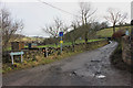
Hedge Row, Berristall Dale
Single lane with passing places (infrequent) in reality an extended entrance drive to the farmsteads and dwellings up the dale.
Image: © Peter Turner
Taken: 23 Feb 2012
0.01 miles
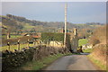
2
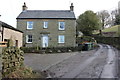
The Cheshire Hunt
As the Cheshire Hunt Inn it was once a popular hostelry, but probably not popular enough as it is now a private dwelling and has been restored and extended.
Image: © Peter Turner
Taken: 23 Feb 2012
0.03 miles
3
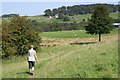
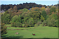
Gritstone Trail near Harrop Brook
The wooded valley of Harrop Brook is seen just above centre below Berristall Hall.
Image: © Peter Standing
Taken: 10 Sep 2006
0.06 miles
4
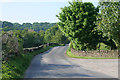
Spuley Lane
Looking north from Hedge Row. This part of the Peak District National Park at about 200 metres above sea level is heavily wooded.
Image: © Kate Jewell
Taken: 15 May 2008
0.07 miles
5
Near Sowcar
Field near Sowcar, Bollington.
Image: © Wayland Smith
Taken: 12 Oct 2019
0.08 miles
6
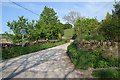
Hedge Row
The Gritstone Trail follows this narrow country road for a few hundred yards before heading off across farmland to the Harrop Brook, while the public footpath continues along to the end of the lane to Bower Clough in Image
Image: © Kate Jewell
Taken: 15 May 2008
0.08 miles
7

Junction at Ormes Smithy
Looking down Spuley Lane
Image: © Philip Cornwall
Taken: 6 May 2020
0.10 miles
8
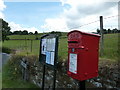
Spuley Lane
Rainow Parish Council notices and a GR post box.
Image: © Peter Barr
Taken: 4 Aug 2014
0.10 miles
9
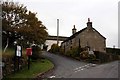
Cottages on Spuley Lane
Two minor roads cross here with the cottages sitting in the middle of the junction.
Image: © Graham Hogg
Taken: 7 Nov 2012
0.11 miles
10
Oakenbank Lane
At the junction with Ingersley Road/Blaze Hill.
Image: © Peter Turner
Taken: 26 Feb 2016
0.13 miles