IMAGES TAKEN NEAR TO
Century Way, MACCLESFIELD, SK10 2RB
Introduction
This page details the photographs taken nearby to Century Way, SK10 2RB by members of the Geograph project.
The Geograph project started in 2005 with the aim of publishing, organising and preserving representative images for every square kilometre of Great Britain, Ireland and the Isle of Man.

There are currently over 7.5m images from over14,400 individuals and you can help contribute to the project by visiting https://www.geograph.org.uk
Image Map
Images are licensed for reuse under creativecommons.org/licenses/by-sa/2.0
Notes
- Clicking on the map will re-center to the selected point.
- The higher the marker number, the further away the image location is from the centre of the postcode.
Image Listing (30 Images Found)
Images are licensed for reuse under creativecommons.org/licenses/by-sa/2.0
Image
Details
Distance
1
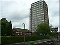
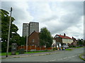
Carisbrook Avenue, Hurdsfield, Macclesfield
The building to the left of the high-rise is Carisbrook Chapel.
Image: © Jonathan Billinger
Taken: 3 Sep 2008
0.12 miles
2
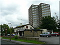
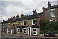
The Mulberry Bush, Carisbrook Avenue, Hurdsfield
Suburban pub with friendly attitude in this eastern suburb of Macclesfield full of typical 1960's urban architecture.
Image: © Jonathan Billinger
Taken: 3 Sep 2008
0.13 miles
5
Housing in Hurdsfield
This suburb of Macclesfield is centred on high ground to the east of the town.
Image: © Jonathan Billinger
Taken: 3 Sep 2008
0.18 miles
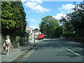
7
Britannia Inn, Hurdsfield Road
Macclesfield pub on the B5470 road.Freehouse for sale, 810 year lease.
Image: © Peter Barr
Taken: 30 Jun 2014
0.19 miles
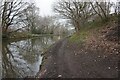
8
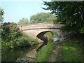
Bridge number 33, Macclesfield Canal
This bridge appears to lead nowhere according to the map. To the left it backs onto the houses on Delamere Drive, Hurdsfield.
Image: © michael ely
Taken: 16 Oct 2006
0.20 miles
9
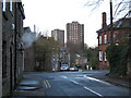
Hurdsfield flats, Macclesfield
Looking from Trinity Square across Hurdsfield Road and down Masons Lane. The steam is from the laundrette on the corner. The building on the right is the Flower Pot Inn Image One block of flats appears in Image and other photos.
Image: © Robin Stott
Taken: 4 Dec 2009
0.21 miles
10
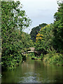
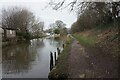
Macclesfield Canal near Hurdsfield in Cheshire
Looking north towards Bollington and Marple. Higherfold Bridge, No 80, is about eighty metres ahead.
Image: © Roger Kidd
Taken: 8 Sep 2014
0.21 miles