IMAGES TAKEN NEAR TO
Baldock Road, BUNTINGFORD, SG9 9PN
Introduction
This page details the photographs taken nearby to Baldock Road, SG9 9PN by members of the Geograph project.
The Geograph project started in 2005 with the aim of publishing, organising and preserving representative images for every square kilometre of Great Britain, Ireland and the Isle of Man.

There are currently over 7.5m images from over14,400 individuals and you can help contribute to the project by visiting https://www.geograph.org.uk
Image Map
Images are licensed for reuse under creativecommons.org/licenses/by-sa/2.0
Notes
- Clicking on the map will re-center to the selected point.
- The higher the marker number, the further away the image location is from the centre of the postcode.
Image Listing (74 Images Found)
Images are licensed for reuse under creativecommons.org/licenses/by-sa/2.0
Image
Details
Distance
1
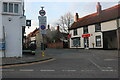
Buntingford Village Sign
Bunting on the top and showing the flags of France and Spain, as the town is twinned with Luynes in France and Olvega in Spain.
Image: © Eirian Evans
Taken: 10 Sep 2009
0.02 miles
2
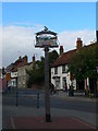
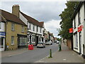
Buntingford Market Place and High Street
This image was taken at the north end of Buntingford's Market Place, looking along the High Street.
The high street lies on the route of Ermine Street, a Roman road. It formed part of the route of the A10 trunk road, until a by-pass was built to divert through traffic away from the town centre.
A traditional town sign stands to the left of the image.
Image: © Malc McDonald
Taken: 25 Sep 2022
0.02 miles
4
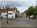
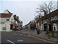
Buntingford High Street
The high street in Buntingford, a market town in north Hertfordshire. This road lies on the route of Ermine Street, a Roman road. It formed part of the route of the A10 trunk road, until a by-pass was built to divert through traffic away from the town centre.
Image: © Malc McDonald
Taken: 25 Sep 2022
0.03 miles
5
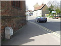
Junction of Baldock Road and High Street Buntingford
Image: © Bikeboy
Taken: 2 Dec 2013
0.03 miles
8
Old Milepost
Old milepost on what was the A.10 at Buntingford, Hertfordshire for close up view see http://www.geograph.org.uk/photo/1790347
Image: © Keith Evans
Taken: 6 Apr 2010
0.03 miles
9
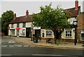
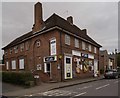
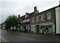
The Black Horse, Buntingford
This was probably a coaching inn when High Street was the main road. According to the large-scale OS map the road was originally Ermine Street, a Roman road.
Image: © Humphrey Bolton
Taken: 29 Jun 2024
0.03 miles