IMAGES TAKEN NEAR TO
Cherry Green, BUNTINGFORD, SG9 9NQ
Introduction
This page details the photographs taken nearby to Cherry Green, SG9 9NQ by members of the Geograph project.
The Geograph project started in 2005 with the aim of publishing, organising and preserving representative images for every square kilometre of Great Britain, Ireland and the Isle of Man.

There are currently over 7.5m images from over14,400 individuals and you can help contribute to the project by visiting https://www.geograph.org.uk
Image Map
Images are licensed for reuse under creativecommons.org/licenses/by-sa/2.0
Notes
- Clicking on the map will re-center to the selected point.
- The higher the marker number, the further away the image location is from the centre of the postcode.
Image Listing (11 Images Found)
Images are licensed for reuse under creativecommons.org/licenses/by-sa/2.0
Image
Details
Distance

3
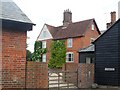
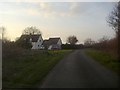
Cherry Green Farmhouse
Originally built in C17. See http://www.britishlistedbuildings.co.uk/en-161354-cherry-green-farmhouse-westmill-hertford#.VYnC_PlViko for entry in British Listed Buildings
Image: © Bikeboy
Taken: 21 Jun 2015
0.03 miles
4
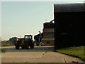
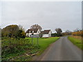
Cherry Green Farm, close to Westmill, Herts.
Image: © Robert Edwards
Taken: 16 Oct 2006
0.04 miles
6
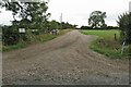
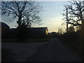
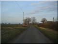
Entering Cherry Green
Apart from one house the other side of the village these are the total of buildings here between the boundary markers.
Image: © David Howard
Taken: 6 Mar 2012
0.08 miles