IMAGES TAKEN NEAR TO
Bridgefoot, BUNTINGFORD, SG9 9HL
Introduction
This page details the photographs taken nearby to Bridgefoot, SG9 9HL by members of the Geograph project.
The Geograph project started in 2005 with the aim of publishing, organising and preserving representative images for every square kilometre of Great Britain, Ireland and the Isle of Man.

There are currently over 7.5m images from over14,400 individuals and you can help contribute to the project by visiting https://www.geograph.org.uk
Image Map
Images are licensed for reuse under creativecommons.org/licenses/by-sa/2.0
Notes
- Clicking on the map will re-center to the selected point.
- The higher the marker number, the further away the image location is from the centre of the postcode.
Image Listing (69 Images Found)
Images are licensed for reuse under creativecommons.org/licenses/by-sa/2.0
Image
Details
Distance
1
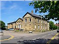
Former Buntingford Union Workhouse
I noticed this grim old building at the southern end of the old part of the town, in the angle between the High Street and the Hare Street road. The street name, Union Terrace, left me in little doubt that this was once the local workhouse. According to the town website, it dates from circa 1837: http://www.buntingfordtowncouncil.co.uk/history.php
Not many old workhouses survive, so I was surprised to find that this one is not a Listed Building - its lack of charm should not disqualify it. Oddly, a local 'K6' type phone-box (still a commonplace sight in some parts of the country) has achieved Listed status, but not the workhouse.
Image: © Stefan Czapski
Taken: 30 Jun 2013
0.02 miles
2
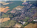
Buntingford from the air
Looking south across Ermine Street and the bypass [A10].
Image: © M J Richardson
Taken: 12 Jul 2017
0.03 miles
3
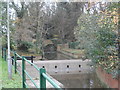
Footbridge, Buntingford
Carries a small road called "The Tannery"
Image: © Bikeboy
Taken: 2 Dec 2013
0.03 miles
4

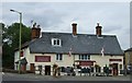
'The Jolly Sailors' public house in Buntingford
This stands on the corner of the road junction where Hare Street Road meets Station Road.
Image: © Robert Edwards
Taken: 29 Apr 2009
0.06 miles
6
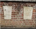
Old Boundary Markers by the B1038, Buntingford Bridge, Buntingford parish
Boundary Marker by the B1038, in parish of Buntingford (East Hertfordshire District), Buntingford Bridge over River Rib, East bridge parapet.
Inscriptions read:-
LEFT:
N M
1766
RIGHT:
W Z
1766
Surveyed
Milestone Society National ID: HE_BUNT02bm
Image: © Milestone Society
Taken: Unknown
0.06 miles
7
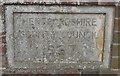
Old Bridge Marker by the B1038, Buntingford Bridge
Bridge Marker by the B1038, in parish of Buntingford (East Hertfordshire District), Buntingford Bridge over River Rib, West bridge parapet.
Inscription reads:- : HERTFORDSHIRE / COUNTY COUNCIL / 1937 :
Surveyed
Milestone Society National ID: HE_BUNT01br
Image: © Milestone Society
Taken: Unknown
0.08 miles
8
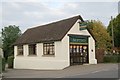
Buntingford old fire station
Buntingford old fire station, Station Road, Buntingford, Hertfordshire, was replaced by Image and is now used as a funeral parlour
Image: © Kevin Hale
Taken: 7 Oct 2007
0.08 miles
9
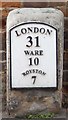
Old Milestone by the B1038, High Street, Buntingford
Metal plate attached to stone post by the B1038, in parish of BUNTINGFORD (EAST HERTFORDSHIRE District), High Street, outside St. Peters church, in pavement against wall of church, on West side of road. Wadesmill plate, erected by the Wadesmill turnpike trust in the 19th century.
Inscription reads:-
LONDON
31
WARE
10
ROYSTON
7
Grade II listed. List Entry Number: 1295819
https://historicengland.org.uk/listing/the-list/list-entry/1295819
Milestone Society National ID: HE_LK31.
Image: © MW Hallett
Taken: 11 Aug 2002
0.08 miles
10
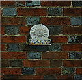
Sun Fire Insurance mark, Buntingford
For a comprehensive history of British fire insurance marks follow this http://www.firemarks.co.uk/home.htm.
Image: © Jim Osley
Taken: 15 Oct 2011
0.08 miles