IMAGES TAKEN NEAR TO
Station Yard, BUNTINGFORD, SG9 9FH
Introduction
This page details the photographs taken nearby to Station Yard, SG9 9FH by members of the Geograph project.
The Geograph project started in 2005 with the aim of publishing, organising and preserving representative images for every square kilometre of Great Britain, Ireland and the Isle of Man.

There are currently over 7.5m images from over14,400 individuals and you can help contribute to the project by visiting https://www.geograph.org.uk
Image Map
Images are licensed for reuse under creativecommons.org/licenses/by-sa/2.0
Notes
- Clicking on the map will re-center to the selected point.
- The higher the marker number, the further away the image location is from the centre of the postcode.
Image Listing (22 Images Found)
Images are licensed for reuse under creativecommons.org/licenses/by-sa/2.0
Image
Details
Distance
1
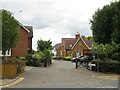
Station Yard, Buntingford
Station Yard is a small residential development on the outskirts of Buntingford, in north Hertfordshire. As its name suggests, it occupies the site of Buntingford's railway station which closed to passengers in 1964. The building to the right of the image is the former station building.
Image: © Malc McDonald
Taken: 25 Sep 2022
0.02 miles
2
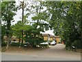
Nutslip, Buntingford
Nutslip is a small residential cul-de-sac on the outskirts of Buntingford, a market town in north Hertfordshire.
Image: © Malc McDonald
Taken: 25 Sep 2022
0.03 miles
3
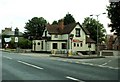
'The Railway' inn, Buntingford, Herts.
The main road in the picture is the old A.10, which is part of the Roman road, Ermine Street. The side road on the right leads to Aspenden.
Image: © Robert Edwards
Taken: 4 Aug 2006
0.07 miles
4
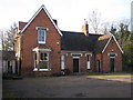
Buntingford: Former railway station
"Next train's gone!" to quote Jeremiah Harbottle in the Will Hay film "Oh Mr Porter". Well this may not quite be Buggleskelly but the last passenger train left Buntingford station in 1964. Despite this the building appears to be generally in remarkably good condition. It was built at the end of the 13¾ mile long branch line from St Margarets near Ware, and was opened in 1863. Closure to passengers came in 1964 whilst a goods service lingered for another year. So the building served the community for 102 years but has been disused as a passenger railway station for the last 43 years. There is however a notice fixed to the building stating that a planning application has been made to convert the station house to three dwellings, with other houses to be built too. The station is off the road to Aspenden and is just visible to the right in Robert's Image
Image: © Nigel Cox
Taken: 25 Nov 2007
0.07 miles
5
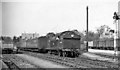
Buntingford Station, with train
View northward, to buffer-stops; ex-Great Eastern branch from St Margaret's. The station and branch were closed to passengers 16/11/64, to goods 20/9/65. A Class N7 0-6-2T is working the branch train.
Image: © Ben Brooksbank
Taken: 4 Apr 1959
0.08 miles
6
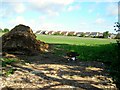
Houses and field
. . . with impressive muck heap, waiting to be spread. The houses are on Barleycroft and Knights Close.
Image: © Antony Dixon
Taken: 11 Aug 2014
0.17 miles
9
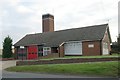
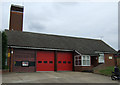
Buntingford fire station
Buntingford fire station, Station Road, Buntingford, Hertfordshire, is a few hundred yards from the old fire station which it replaced Image
Image: © Kevin Hale
Taken: 7 Oct 2007
0.20 miles
10
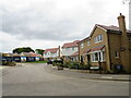
Abrahams Drive, Buntingford
Abrahams Drive forms part of a newly-built housing development on the outskirts of Buntingford in north Hertfordshire.
Image: © Malc McDonald
Taken: 25 Sep 2022
0.20 miles