IMAGES TAKEN NEAR TO
Chipping, BUNTINGFORD, SG9 0PQ
Introduction
This page details the photographs taken nearby to SG9 0PQ by members of the Geograph project.
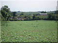
The Geograph project started in 2005 with the aim of publishing, organising and preserving representative images for every square kilometre of Great Britain, Ireland and the Isle of Man.

There are currently over 7.5m images from over14,400 individuals and you can help contribute to the project by visiting https://www.geograph.org.uk
Image Map
Images are licensed for reuse under creativecommons.org/licenses/by-sa/2.0
Notes
- Clicking on the map will re-center to the selected point.
- The higher the marker number, the further away the image location is from the centre of the postcode.
Image Listing (26 Images Found)
Images are licensed for reuse under creativecommons.org/licenses/by-sa/2.0
Image
Details
Distance
1
Ermine Street
Roman Road leaving Chipping.
Image: © Hugh Venables
Taken: 5 Oct 2014
0.03 miles
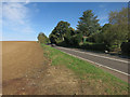
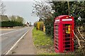
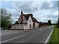
2
A10 heading north
Passing through Chipping.
Image: © Robin Webster
Taken: 12 Feb 2018
0.06 miles
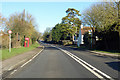
4
View of the village from Chipping Hill
Image: © Simon Mortimer
Taken: 19 Jun 2007
0.07 miles
5
Roadside defibrillator box in Chipping
Image: © Philip Jeffrey
Taken: 9 Apr 2023
0.09 miles
6
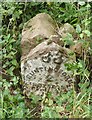
Old Milestone by the A10, Ermine Street, Chipping Hill, Buckland
Metal plate attached to stone post by the A10, in parish of Buckland (East Hertfordshire District), Chipping Hill, North of Chipping, on the verge, on West side of road. Wadesmill plate, erected by the Wadesmill turnpike trust in the 19th century. Stone and plate badly broken.
Inscription reads:-
(LONDON)
33
BUNTINGFORD
2
Royston
5
Hertfordshire HER & St Albans UAD.
HHER Number: 5044 https://www.heritagegateway.org.uk/Gateway/Results_Single.aspx?uid=MHT5044&resourceID=1008
Milestone Society National ID: HE_LK33
Image: © MW Hallett
Taken: 11 Aug 2002
0.09 miles
7
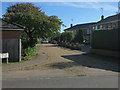
Royal Oak Close
Private road in Chipping.
Image: © Hugh Venables
Taken: 5 Oct 2014
0.10 miles
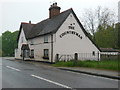
8
The Countryman pub, Ermine Street
Built in the late C16/early C17 as a house. See http://www.britishlistedbuildings.co.uk/en-160266-the-countryman-public-house-opposite-chi#.VV5CLPlViko for entry in British Listed Buildings.
The road is the A10 between London and Cambridge. This last stretch to Cambridge is the only part which is not dual carriageway. This section follows the course of Ermine Street-the Roman Road between London and Lincoln.
Image: © Bikeboy
Taken: 17 May 2015
0.15 miles