IMAGES TAKEN NEAR TO
Royal Oak Close, BUNTINGFORD, SG9 0PF
Introduction
This page details the photographs taken nearby to Royal Oak Close, SG9 0PF by members of the Geograph project.
The Geograph project started in 2005 with the aim of publishing, organising and preserving representative images for every square kilometre of Great Britain, Ireland and the Isle of Man.

There are currently over 7.5m images from over14,400 individuals and you can help contribute to the project by visiting https://www.geograph.org.uk
Image Map
Images are licensed for reuse under creativecommons.org/licenses/by-sa/2.0
Notes
- Clicking on the map will re-center to the selected point.
- The higher the marker number, the further away the image location is from the centre of the postcode.
Image Listing (26 Images Found)
Images are licensed for reuse under creativecommons.org/licenses/by-sa/2.0
Image
Details
Distance
1
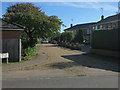
Royal Oak Close
Private road in Chipping.
Image: © Hugh Venables
Taken: 5 Oct 2014
0.01 miles
2
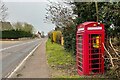
Roadside defibrillator box in Chipping
Image: © Philip Jeffrey
Taken: 9 Apr 2023
0.03 miles
3
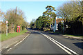
A10 heading north
Passing through Chipping.
Image: © Robin Webster
Taken: 12 Feb 2018
0.05 miles

5
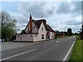
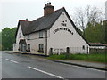
The Countryman pub, Ermine Street
Built in the late C16/early C17 as a house. See http://www.britishlistedbuildings.co.uk/en-160266-the-countryman-public-house-opposite-chi#.VV5CLPlViko for entry in British Listed Buildings.
The road is the A10 between London and Cambridge. This last stretch to Cambridge is the only part which is not dual carriageway. This section follows the course of Ermine Street-the Roman Road between London and Lincoln.
Image: © Bikeboy
Taken: 17 May 2015
0.05 miles
7
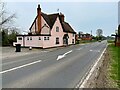
The Countryman Inn
It has a distinctly closed look about it, another ex pub I think.
Image: © Philip Jeffrey
Taken: 9 Apr 2023
0.06 miles
8
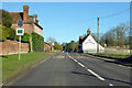
A10 heading north, Chipping
The early 18th century Chipping Hall and the 16th/17th century Countryman Inn face each other across the road. Both are grade II listed buildings.
Image: © Robin Webster
Taken: 12 Feb 2018
0.06 miles
9
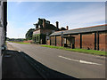
Chipping Hall
On Ermine Street, a Roman Road through Chipping.
Image: © Hugh Venables
Taken: 5 Oct 2014
0.07 miles
10
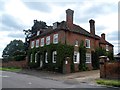
Chipping Hall
Built early in C18. See http://www.britishlistedbuildings.co.uk/en-160269-chipping-hall-and-garden-walls-buckland-#.VV5CMflViko for entry in British Listed Buildings
This part of the A10 is the former Roman Road of Ermine Street which linked London and Lincoln.
Image: © Bikeboy
Taken: 17 May 2015
0.08 miles