IMAGES TAKEN NEAR TO
The Street, ROYSTON, SG8 9SQ
Introduction
This page details the photographs taken nearby to The Street, SG8 9SQ by members of the Geograph project.
The Geograph project started in 2005 with the aim of publishing, organising and preserving representative images for every square kilometre of Great Britain, Ireland and the Isle of Man.

There are currently over 7.5m images from over14,400 individuals and you can help contribute to the project by visiting https://www.geograph.org.uk
Image Map
Images are licensed for reuse under creativecommons.org/licenses/by-sa/2.0
Notes
- Clicking on the map will re-center to the selected point.
- The higher the marker number, the further away the image location is from the centre of the postcode.
Image Listing (15 Images Found)
Images are licensed for reuse under creativecommons.org/licenses/by-sa/2.0
Image
Details
Distance
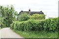
1

Houses at Kelsall, in front of St Mary's Church, Therfield
Image: © David Martin
Taken: 25 May 2024
0.08 miles
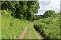
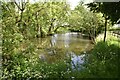
3
Chain Walk (or Duck's Green)
The different maps don't agree on the name of this byway.
Image: © Hugh Venables
Taken: 5 Oct 2014
0.16 miles
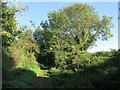
7
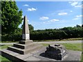
Kelshall Cross and millennium monument
The base is all that remains of this medieval cross. By 1795 the stump must have been well known since it gave its name to a nearby piece of land (Stump Cross Field). There is another medieval cross in Kelshall in the church yard (see http://www.geograph.org.uk/photo/4499).
The obelisk was erected to mark the new millennium.
Image: © Bikeboy
Taken: 7 Jun 2015
0.23 miles
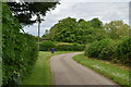
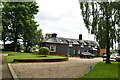
10
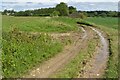
Track between fields south of Kelshall
This permissive route is signed locally as the Hertfordshire Way (Clockwise Direction). Although up on the chalk downs, there is an overlying layer of boulder clay, making the going surprisingly muddy.
Image: © David Martin
Taken: 25 May 2024
0.24 miles