IMAGES TAKEN NEAR TO
Park Farm Lane, ROYSTON, SG8 8LZ
Introduction
This page details the photographs taken nearby to Park Farm Lane, SG8 8LZ by members of the Geograph project.
The Geograph project started in 2005 with the aim of publishing, organising and preserving representative images for every square kilometre of Great Britain, Ireland and the Isle of Man.

There are currently over 7.5m images from over14,400 individuals and you can help contribute to the project by visiting https://www.geograph.org.uk
Image Map
Images are licensed for reuse under creativecommons.org/licenses/by-sa/2.0
Notes
- Clicking on the map will re-center to the selected point.
- The higher the marker number, the further away the image location is from the centre of the postcode.
Image Listing (15 Images Found)
Images are licensed for reuse under creativecommons.org/licenses/by-sa/2.0
Image
Details
Distance
1

Fishing Pond, Nuthampstead
The Lake is on the edge of the former WWII Airfield called Nuthampstead. A short Airstrip still remains but the Airfield is now farmland.
Image: © Richard Thomas
Taken: 14 Jul 2006
0.02 miles
2
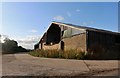
RAF Nuthampstead
Park Farm, occupying the site of an old RAF/USAAF airfield https://en.wikipedia.org/wiki/RAF_Nuthampstead.
Image: © M J Richardson
Taken: 12 Jul 2017
0.07 miles
4
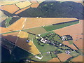
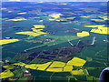
Former RAF Nuthampstead from the air
The RAF base closed in 1959. Click on this http://en.wikipedia.org/wiki/RAF_Nuthampstead to go to the wikipedia article about the base. Viewed from a Luton bound flight from Prague.
See also Image & Image
Image: © Thomas Nugent
Taken: 11 May 2012
0.12 miles
5
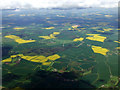
Former RAF Nuthampstead from the air
The RAF base closed in 1959. Click on this http://en.wikipedia.org/wiki/RAF_Nuthampstead to go to the wikipedia article about the base. Viewed from a Luton bound flight from Prague.
See also Image & Image
Image: © Thomas Nugent
Taken: 11 May 2012
0.12 miles
6
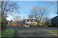
Nuthampstead: Bull's Farm
The Grade II listing text for the farmhouse begins "Mid C17, altered and extended C20. Timber frame. Rendered. Steeply pitched half-hipped tiled roof."
Image: © John Sutton
Taken: 17 Jan 2023
0.19 miles
7
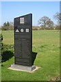
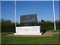
Fighter Group Memorial, Nuthampstead
Memorial next to "The Woodman" pub, dedicated to the pilots of 55th Fighter Group,442nd Air Service Group, 66th Fighter Wing and VIII Fighter Command, USAAF - who were lost in combat while based at RAF Nuthampstead.
Image: © Lorraine and Keith Bowdler
Taken: 17 Apr 2010
0.19 miles
8
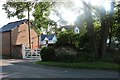
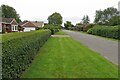
Farmstead in Nuthampstead
A house with a barn and outbuildings in the yard, all apparently now converted.
Image: © David Howard
Taken: 20 Jul 2019
0.19 miles
9
398th Bomb Group Memorial, Nuthampstead
Memorial situated near "The Woodman" pub.
Image: © Lorraine and Keith Bowdler
Taken: 17 Apr 2010
0.20 miles