1
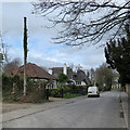
Meldreth High Street
The brick house to the right, The Court, though dated 1892 in terra cotta, is much older, with 17th- and 18th-century elements - see http://www.britishlistedbuildings.co.uk/en-52281-the-court-meldreth-cambridgeshire . The cottage on the left is also listed - see http://www.britishlistedbuildings.co.uk/en-52275-applecote-meldreth-cambridgeshire .
Image: © John Sutton
Taken: 13 Mar 2014
0.09 miles
2
Meldreth High Street: stinkpipe, bungalow and thatch
Looking towards the junction of Fenny Lane and North End on a cloudy March morning. The ivy-wreathed stinkpipe on the left, one of seven in the village, is the chunky concrete-cased type found in several other South Cambridgeshire villages.
The other six:
Image]
Image]
Image]
Image]
Image]
Image]
For more about Meldreth’s stinkpipes, try the informative village website: https://www.meldrethhistory.org.uk/the-village/village-wide_information/stink_stench_pipes_of_meldreth .
Image: © John Sutton
Taken: 25 Mar 2021
0.09 miles
3
Meldreth: Village Stocks and Whipping Post
Nearly hidden at the base of this magnificent horse chestnut tree and only just visible as four holes immediately to the right of the tree trunk are the village stocks. These are surprisingly mentioned on the Ordnance Survey 1:10,000 scale mapping along with the whipping post. The base of the whipping post can be seen just to the right of the stocks. The triangular area is known as Marvell's Green and is at the junction of three roads, the High Street, Fenny Lane and North End.
Image: © Nigel Cox
Taken: 6 Jul 2008
0.11 miles
4
Meldreth cross base
This medieval limestone cross base is on the grass triangle at the junction of Fenny Lane, High Street, and North End.
Image: © Ben Harris
Taken: 18 Dec 2021
0.11 miles
5
Meldreth stocks, whipping post, and cross base
Image: © Ben Harris
Taken: 18 Dec 2021
0.11 miles
6
Greenwich meridian marker at Meldreth
Image: © Dennis Troughton
Taken: 15 Oct 2005
0.11 miles
7
Meldreth: Marvell's green bus stop shelter and finger post
The rather stubby finger post has the following directions and mileages:-
Shepreth 2 Barrington 4 (to the left)
Meldreth Station ½ Melbourn and Royston (to the right)
Whaddon 1½ Kneesworth 3 (to the photographer)
Image: © Nigel Cox
Taken: 6 Jul 2008
0.12 miles
8
Carved village sign, Meldreth
Dated 1977 for the Queen's silver jubilee.
Image: © Bikeboy
Taken: 7 Dec 2014
0.12 miles
9
Old Direction Sign - Signpost by High Street, Meldreth
No finial - 3 arms; by the UC road, in parish of Meldreth (South Cambridgeshire District), junction of Manor Road with North End and High Street, Meldreth, on grass verge by bus shelter.
Surveyed
Milestone Society National ID: CA_TL3746
Image: © Milestone Society
Taken: Unknown
0.13 miles
10
Meldreth: Emilie Agnes Elin Almshouses
The local history website explains that these almshouses, built thanks to a bequest from Mrs Elin, date from 1956 - see http://www.meldrethhistory.org.uk/page_id__174_path__0p2p54p.aspx .
Image: © John Sutton
Taken: 13 Mar 2014
0.14 miles


