IMAGES TAKEN NEAR TO
New Road, ROYSTON, SG8 6FD
Introduction
This page details the photographs taken nearby to New Road, SG8 6FD by members of the Geograph project.
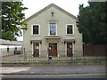
The Geograph project started in 2005 with the aim of publishing, organising and preserving representative images for every square kilometre of Great Britain, Ireland and the Isle of Man.

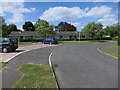
There are currently over 7.5m images from over14,400 individuals and you can help contribute to the project by visiting https://www.geograph.org.uk
Image Map
Images are licensed for reuse under creativecommons.org/licenses/by-sa/2.0
Notes
- Clicking on the map will re-center to the selected point.
- The higher the marker number, the further away the image location is from the centre of the postcode.
Image Listing (81 Images Found)
Images are licensed for reuse under creativecommons.org/licenses/by-sa/2.0
Image
Details
Distance
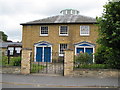
1
Melbourn: Clear Cottages
These almshouses on Orchard Road were built in 1924 as a philanthropic act by W W Clear who left £1,500 to build almshouses on a site provided from his estate. They were to be named after his brother, Francis John Clear, who died around 1905, and were for poor women who had been resident in Melbourn for at least 10 years.
Image: © Nigel Cox
Taken: 6 Jul 2008
0.05 miles
2
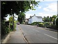
Orchard Road toward Mortlock Street Melbourn
Image: © Martin Dawes
Taken: 15 Aug 2015
0.06 miles
3
Melbourn United Reformed Church
This building in Orchard Road was constructed in 1717. Since the United Reformed Church was only created in 1972 by the union of the Congregational and Presbyterian Churches it was obviously not originally built as such.
Image: © Nigel Cox
Taken: 6 Jul 2008
0.07 miles
4
Melbourn Baptist Church
Much renovated and refurbished over the years, the Baptist Church in Mortlock Street was built in 1856. The Church appears to be very active and has an excellent website here http://www.melbourn-baptist.org.uk/index.php
Image: © Nigel Cox
Taken: 6 Jul 2008
0.07 miles
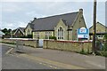
5
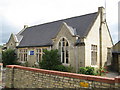
Melbourn County Primary School
The School is on the east side of Mortlock Street.
Image: © Nigel Cox
Taken: 6 Jul 2008
0.08 miles
6
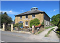
Melbourn United Reformed Church
The Grade II listing begins “Congregational meeting house c 1716, enlarged at the south end in 1815 and to the rear c 1830. Brick, rendered, with the 1815 front wall of amber brickwork and some stone detail. Hipped slate roof rising to a lantern, replaced by a polygonal cupola with a shallow domed roof covered with copper”.
Image: © John Sutton
Taken: 13 Jun 2020
0.09 miles
7
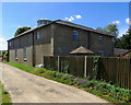
Melbourn: the rear of the United Reformed Church
A summer-morning view from Chapel Lane. This was built as a Congregational Meeting House about 1716. For more about it, see Image] taken a short while earlier.
Image: © John Sutton
Taken: 13 Jun 2020
0.09 miles
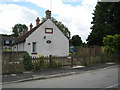
9
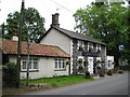
Melbourn: Black Horse public house
This attractive flint-built pub is in Orchard Road.
Image: © Nigel Cox
Taken: 6 Jul 2008
0.10 miles