IMAGES TAKEN NEAR TO
Malting Lane, ROYSTON, SG8 0QU
Introduction
This page details the photographs taken nearby to Malting Lane, SG8 0QU by members of the Geograph project.
The Geograph project started in 2005 with the aim of publishing, organising and preserving representative images for every square kilometre of Great Britain, Ireland and the Isle of Man.

There are currently over 7.5m images from over14,400 individuals and you can help contribute to the project by visiting https://www.geograph.org.uk
Image Map
Images are licensed for reuse under creativecommons.org/licenses/by-sa/2.0
Notes
- Clicking on the map will re-center to the selected point.
- The higher the marker number, the further away the image location is from the centre of the postcode.
Image Listing (101 Images Found)
Images are licensed for reuse under creativecommons.org/licenses/by-sa/2.0
Image
Details
Distance
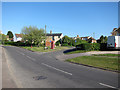
1
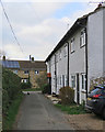
Litlington: cottages and cat
The Middle Street end of Malting Lane on a cloudy Sunday morning in late November.
Image: © John Sutton
Taken: 25 Nov 2018
0.02 miles
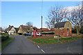
2
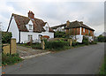
Litlington: Grove House and Coronation House
Two Grade II listed 19th-century timber-framed houses on Middle Street.
Image: © John Sutton
Taken: 25 Nov 2018
0.02 miles
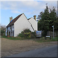
3
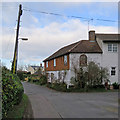
Litlington: the corner of Middle Street and Malting Lane
Coronation House, on the corner, is a Grade II listed 19th-century timber-framed house with cast-iron window frames.
Image: © John Sutton
Taken: 25 Nov 2018
0.02 miles
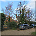
4
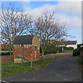
Litlington: the Litlington Cage (or St Peter's Hole)
The Grade II listed village lock-up dates from the 18th century. The yellow-brick barrel roof, weatherproofed with tar, is a 19th-century alteration. The lock-up was last used in 1840. After a brief sunny spell on a late-November morning the sky was clouding over again.
Image: © John Sutton
Taken: 25 Nov 2018
0.04 miles
6
Litlington: listed buildings
The timber-framed houses on the left are Grade II listed, as are the K6 telephone kiosk and the 18th-century village lock-up. For more about the lock-up, see Image
Image: © John Sutton
Taken: 25 Nov 2018
0.05 miles
7
Litlington: the corner of Burr's Lane
The Grade II listing suggests the timber-framed cottage may date from the 18th century, with 19th-century alterations.
Image: © John Sutton
Taken: 25 Nov 2018
0.05 miles
8
Litlington: on Burr's Lane
The thatched and pantiled roofs belong to Burr Cottage, built late in the 17th century, adapted later and Grade II listed.
Image: © John Sutton
Taken: 25 Nov 2018
0.06 miles
9
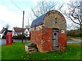
Village lock-up, Litlington
Early C18 with C19 rebuilding. See http://www.britishlistedbuildings.co.uk/en-52583-village-lock-up-litlington-cambridgeshire for entry in British Listed Buildings
See http://www.geograph.org.uk/photo/3928088 http://www.geograph.org.uk/photo/3829795 and http://www.geograph.org.uk/photo/3523950 for other examples of village lock-ups
Image: © Bikeboy
Taken: 7 Dec 2014
0.06 miles
10
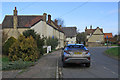
Litlington: Silver Street
Looking towards where Silver Street bends to join Meeting Lane. On a late-November morning a brief sunny spell was about to come to an end.
Image: © John Sutton
Taken: 25 Nov 2018
0.07 miles