IMAGES TAKEN NEAR TO
West End, BALDOCK, SG7 5PH
Introduction
This page details the photographs taken nearby to West End, SG7 5PH by members of the Geograph project.
The Geograph project started in 2005 with the aim of publishing, organising and preserving representative images for every square kilometre of Great Britain, Ireland and the Isle of Man.

There are currently over 7.5m images from over14,400 individuals and you can help contribute to the project by visiting https://www.geograph.org.uk
Image Map
Images are licensed for reuse under creativecommons.org/licenses/by-sa/2.0
Notes
- Clicking on the map will re-center to the selected point.
- The higher the marker number, the further away the image location is from the centre of the postcode.
Image Listing (182 Images Found)
Images are licensed for reuse under creativecommons.org/licenses/by-sa/2.0
Image
Details
Distance
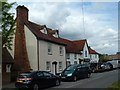
1
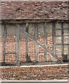
Timber-framed farm building, West End, Ashwell
The bricks used for 'nogging' are a very motley collection, of all shapes and sizes - no doubt made locally, at some stage in the past.
Image: © Stefan Czapski
Taken: 14 Jun 2012
0.01 miles
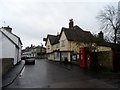
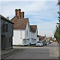
2
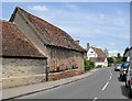
West End, Ashwell
Looking east, towards the parish church. The timber-framed farm building in the foreground is also to be seen here: http://www.geograph.org.uk/photo/2994957
Image: © Stefan Czapski
Taken: 14 Jun 2012
0.02 miles
3
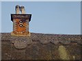
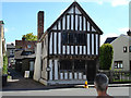
Chimney and thatched roof, Chantry House, Ashwell
The oddest thing about this chimney is that bottle-ends have been set into the brickwork - as decoration. I know of only one other instance of bottles being used in this way, at Coleshill, in Buckinghamshire: Image
Image: © Stefan Czapski
Taken: 19 May 2013
0.03 miles
4
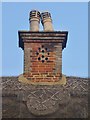
Chimney and thatched roof, Chantry House, Ashwell (2)
The oddest thing about this chimney is that bottle-ends have been set into the brickwork - as decoration.
At the time of taking this photo I knew of only one other instance where bottles were used - inset - to decorate brickwork: Image If I happen on any others, I'll do my best to document them.
Image: © Stefan Czapski
Taken: 19 May 2013
0.03 miles
5
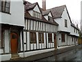
The Rose and Crown pub, Ashwell
The building dates from the late C15. See http://www.britishlistedbuildings.co.uk/en-162162-rose-and-crown-public-house-ashwell-hert for entry in British Listed Buildings
Image: © Bikeboy
Taken: 7 Dec 2014
0.04 miles
6
Ashwell Museum
Not so big as the Victoria and Albert I'll admit.....
The day that this photograph was taken, the Ashwell Show was on and street parking was being controlled - hence the cone.
Image: © Robin Hall
Taken: 29 Aug 2005
0.05 miles
8
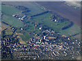
Ashwell from the air
St Mary's Church is prominent near the centre Image
Image: © Thomas Nugent
Taken: 27 Feb 2013
0.05 miles
10
Ashwell: High Street and Dixies Farmhouse
The white house is Grade II listed: http://www.britishlistedbuildings.co.uk/en-162165-dixies-farmhouse-and-dixies-ashwell-hert#.Vv-h7SiwHZY .
Image: © John Sutton
Taken: 1 Apr 2016
0.09 miles