IMAGES TAKEN NEAR TO
Chervil Road, HITCHIN, SG5 4NW
Introduction
This page details the photographs taken nearby to Chervil Road, SG5 4NW by members of the Geograph project.
The Geograph project started in 2005 with the aim of publishing, organising and preserving representative images for every square kilometre of Great Britain, Ireland and the Isle of Man.

There are currently over 7.5m images from over14,400 individuals and you can help contribute to the project by visiting https://www.geograph.org.uk
Image Map
Images are licensed for reuse under creativecommons.org/licenses/by-sa/2.0
Notes
- Clicking on the map will re-center to the selected point.
- The higher the marker number, the further away the image location is from the centre of the postcode.
Image Listing (13 Images Found)
Images are licensed for reuse under creativecommons.org/licenses/by-sa/2.0
Image
Details
Distance
3
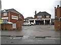
High Street, Stotfold
I suppose this could be said to be the town centre, with bus shelter, shops and public conveniences.
Image: © Humphrey Bolton
Taken: 21 Mar 2018
0.18 miles
6
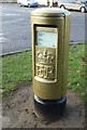
Gold Box on Brook Street, Stotfold
First Gold Box for Victoria Pendleton for her win in Cycling - Women's Keirin
Image: © Kit Slater
Taken: 8 Dec 2012
0.21 miles
8
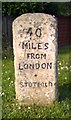
Old Milestone, A1, High Street, Stotford
The milestone is located by No. 29, High Street, 160m south of the junction with Regent Street, on the grass verge, on the east side of road - originally on the west side of the road. Parish of Stotford (Mid Bedfordshire District). Carved stone post, erected by the Stevenage & Biggleswade turnpike trust in the 19th century.
Inscription reads:-
40 / MILES / FROM / LONDON / + / STOTFORD
Milestone Society National ID: BD_LY40
Image: © Robin Hall
Taken: Unknown
0.21 miles
9

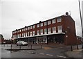
Stotfold Methodist Church.
This imposing building dominates the corner of Hitchin Rd and High Street, Stotfold.
Image: © Robin Hall
Taken: 30 Oct 2005
0.22 miles