IMAGES TAKEN NEAR TO
Alexander Road, HITCHIN, SG5 4NA
Introduction
This page details the photographs taken nearby to Alexander Road, SG5 4NA by members of the Geograph project.
The Geograph project started in 2005 with the aim of publishing, organising and preserving representative images for every square kilometre of Great Britain, Ireland and the Isle of Man.

There are currently over 7.5m images from over14,400 individuals and you can help contribute to the project by visiting https://www.geograph.org.uk
Image Map (Loading...)


Getting Data...Please wait
Leaflet Map data © OpenStreetMap
Images are licensed for reuse under creativecommons.org/licenses/by-sa/2.0
Notes
- Clicking on the map will re-center to the selected point.
- The higher the marker number, the further away the image location is from the centre of the postcode.
Image Listing (27 Images Found)
Images are licensed for reuse under creativecommons.org/licenses/by-sa/2.0
Image
Details
Distance
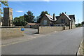
2
The Old School House, Stotfold
Dated 1808, this is now a private residence.
Image: © David Purchase
Taken: 13 Nov 2014
0.09 miles
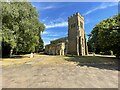
5
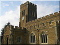
Stotfold, St Mary the Virgin
The bells here form a ring of 8 in the key of G, the tenor weighing 11-0-2
Image: © Matthew Sheasby
Taken: 28 Sep 2013
0.13 miles
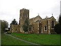
6
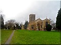
St Mary the Virgin
The earliest parts of the church are C12. Alterations and additions were made in C13, C14 and C15.
Image: © Bikeboy
Taken: 22 Dec 2014
0.13 miles
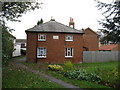
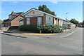
7
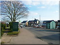
High Street, Stotfold
I suppose this could be said to be the town centre, with bus shelter, shops and public conveniences.
Image: © Humphrey Bolton
Taken: 21 Mar 2018
0.14 miles
8
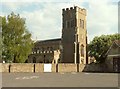
St. Mary the Virgin: the parish church of Stotfold
Parts of the nave date back to the 12th century but most of what is seen today is 15th century after being enlarged during that period.
Image: © Robert Edwards
Taken: 29 Apr 2009
0.14 miles
10
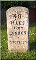
Old Milestone, A1, High Street, Stotford
The milestone is located by No. 29, High Street, 160m south of the junction with Regent Street, on the grass verge, on the east side of road - originally on the west side of the road. Parish of Stotford (Mid Bedfordshire District). Carved stone post, erected by the Stevenage & Biggleswade turnpike trust in the 19th century.
Inscription reads:-
40 / MILES / FROM / LONDON / + / STOTFORD
Milestone Society National ID: BD_LY40
Image: © Robin Hall
Taken: Unknown
0.17 miles