IMAGES TAKEN NEAR TO
Lower Green, HITCHIN, SG5 3TU
Introduction
This page details the photographs taken nearby to Lower Green, SG5 3TU by members of the Geograph project.
The Geograph project started in 2005 with the aim of publishing, organising and preserving representative images for every square kilometre of Great Britain, Ireland and the Isle of Man.

There are currently over 7.5m images from over14,400 individuals and you can help contribute to the project by visiting https://www.geograph.org.uk
Image Map
Images are licensed for reuse under creativecommons.org/licenses/by-sa/2.0
Notes
- Clicking on the map will re-center to the selected point.
- The higher the marker number, the further away the image location is from the centre of the postcode.
Image Listing (11 Images Found)
Images are licensed for reuse under creativecommons.org/licenses/by-sa/2.0
Image
Details
Distance
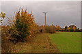
1
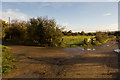
Junction of the lanes leading to Ickleford Common
The gate towards the middle of the image leads into Ickleford Common. The track to the left goes to a private premises and to the right goes into Ickleford Village. The track behind me goes to the Bedford Road eventually. You are not supposed to drive down it as it is gated at the far end, the Google Street View team have ventured down it though!
Image: © Robert Matin
Taken: 14 Nov 2010
0.07 miles
2
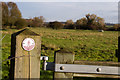
Kissing Gate into Ickleford Common
This is the Southerly entrance to the Common.
Image: © Robert Matin
Taken: 14 Nov 2010
0.09 miles
4
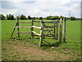
Ickleford: Kissing gate in Lower Green
This kissing gate is on its last legs possibly due to excessive use of it for various purposes by the equine fraternity.
Image: © Nigel Cox
Taken: 13 Jun 2010
0.12 miles
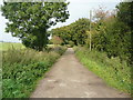
5
Path from Ickleford Common to Snailswell Lane
Image: © Robert Matin
Taken: 3 Nov 2011
0.13 miles
6
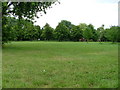
Lower Green.
This photograph is taken from Snailswell Lane (love the name). There is some housing just behind me as I take the photo and a stable behind the trees. There are often horses being ridden in this area. There is a pond plant nursery behind the stables.
Image: © Robin Hall
Taken: 26 Jul 2005
0.15 miles
7
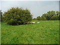
Sheep and trees on Ickleford Common
This is a very pleasant common - grassland with occasional groups of trees. The River Hiz flows past the eastern boundary.
Image: © Humphrey Bolton
Taken: 26 Sep 2017
0.16 miles
8
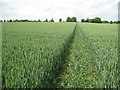
Ickleford: Footpath to Holwell
Looking at old Ordnance Survey maps of the area a public footpath towards Holwell across this field certainly existed in 1884. One wonders how many people have walked across it since...
Image: © Nigel Cox
Taken: 13 Jun 2010
0.17 miles
9
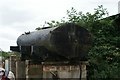
View of a tank in Hitchin Lavender
Looking south-southwest.
Image: © Robert Lamb
Taken: 24 Jul 2016
0.17 miles
10
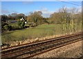
View from a Peterborough-London train - Lower Green Farm
Image: © Nigel Thompson
Taken: 7 Feb 2017
0.20 miles