IMAGES TAKEN NEAR TO
Hillside Close, HITCHIN, SG5 3NN
Introduction
This page details the photographs taken nearby to Hillside Close, SG5 3NN by members of the Geograph project.
The Geograph project started in 2005 with the aim of publishing, organising and preserving representative images for every square kilometre of Great Britain, Ireland and the Isle of Man.

There are currently over 7.5m images from over14,400 individuals and you can help contribute to the project by visiting https://www.geograph.org.uk
Image Map
Images are licensed for reuse under creativecommons.org/licenses/by-sa/2.0
Notes
- Clicking on the map will re-center to the selected point.
- The higher the marker number, the further away the image location is from the centre of the postcode.
Image Listing (50 Images Found)
Images are licensed for reuse under creativecommons.org/licenses/by-sa/2.0
Image
Details
Distance
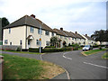
2
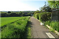
John Bunyan Trail going down to Hillfoot End
Image: © Philip Jeffrey
Taken: 30 May 2021
0.06 miles
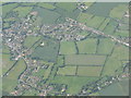
3

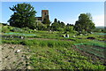
Shillington from the air
All Saints Church and allotments in the lower part of the picture, and the houses are on Hillside Road and Close, Hillfoot Road and Church View Avenue.
Image: © M J Richardson
Taken: 28 Jun 2012
0.09 miles
4
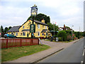
Noah's Ark, Shillington, Beds
on Hillfoot Road, Hillfoot End.
Image: © Rodney Burton
Taken: 27 Jun 2006
0.09 miles
5
Shillington from the air
A circle of small settlements - Shillington, Hillfoot End, Upton End and Woodmer End. Seen from the northeast over the Stondon area. Interesting how the names originated, as the elevation of the whole area does not vary by more than about 10m!
Image: © M J Richardson
Taken: 28 Jun 2012
0.11 miles

8
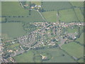
Hillfoot End from the air
The two main roads are Hillfoot Road and Greenfields, the latter, on the right, leading to the Shillington Lower School and playing field.
Image: © M J Richardson
Taken: 28 Jun 2012
0.12 miles
9
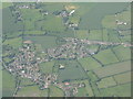
Hillfoot End and Shillington from the air
All Saints Church is to the left, and the roads in the centre are at Hillfoot End. Hanscombe End Road heads upwards out of the picture.
Image: © M J Richardson
Taken: 28 Jun 2012
0.13 miles
