IMAGES TAKEN NEAR TO
St. Albans Road, HITCHIN, SG4 8SP
Introduction
This page details the photographs taken nearby to St. Albans Road, SG4 8SP by members of the Geograph project.
The Geograph project started in 2005 with the aim of publishing, organising and preserving representative images for every square kilometre of Great Britain, Ireland and the Isle of Man.

There are currently over 7.5m images from over14,400 individuals and you can help contribute to the project by visiting https://www.geograph.org.uk
Image Map
Images are licensed for reuse under creativecommons.org/licenses/by-sa/2.0
Notes
- Clicking on the map will re-center to the selected point.
- The higher the marker number, the further away the image location is from the centre of the postcode.
Image Listing (14 Images Found)
Images are licensed for reuse under creativecommons.org/licenses/by-sa/2.0
Image
Details
Distance
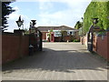
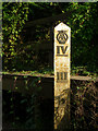
2
St Albans Road
Heading north.
Now but a lane (National Cycle Route 12).
Image: © JThomas
Taken: 22 Feb 2014
0.04 miles
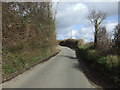
4

Chalk pit
An active chalk quarry occupies a lot of the SW corner of this grid square.
Image: © Rob Hinkley
Taken: 29 Apr 2006
0.11 miles
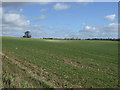
5

Chalk pit
Part of the chalk quarry in the SW of the square.
Image: © Rob Hinkley
Taken: 29 Apr 2006
0.17 miles
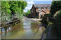
6
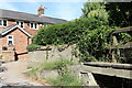
House on St Albans Road, Codicote
Taken from the currently dry ford carrying the River Mimram.
Image: © David Howard
Taken: 7 Aug 2022
0.17 miles
7
AA branded water gauge, near Codicote Bottom
Situated at a ford of the River Mimram.
Image: © Jim Osley
Taken: 8 Oct 2010
0.17 miles
8
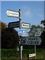
Busy signpost, near Codicote
Situated at a rural crossroads, with direction signs to three towns or villages, a National Trust property (George Bernard Shaw's house), and National Cycle Route no 12 (known as the Great North Way), which currently runs from Letchworth in Hertfordshire to Hadley Wood in North London.
Image: © Jim Osley
Taken: 8 Oct 2010
0.19 miles
9
Codicote Ford
This ford on the River Mimram is found at Codicote. There are two more fords further up stream. Note the unusual AA depth gauge which can be seen in more detail at:
http://www.geograph.org.uk/photo/2106494
Image: © John Walton
Taken: 12 May 2013
0.20 miles
10
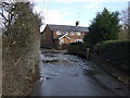
Ford on St Albans Road
The River Mimram just about passable in a normal car. Raised path available for walkers / cyclists (dismounting recommended).
Image: © JThomas
Taken: 22 Feb 2014
0.20 miles