IMAGES TAKEN NEAR TO
Hall Lane, HITCHIN, SG4 8RD
Introduction
This page details the photographs taken nearby to Hall Lane, SG4 8RD by members of the Geograph project.
The Geograph project started in 2005 with the aim of publishing, organising and preserving representative images for every square kilometre of Great Britain, Ireland and the Isle of Man.

There are currently over 7.5m images from over14,400 individuals and you can help contribute to the project by visiting https://www.geograph.org.uk
Image Map (Loading...)


Getting Data...Please wait
Leaflet Map data © OpenStreetMap
Images are licensed for reuse under creativecommons.org/licenses/by-sa/2.0
Notes
- Clicking on the map will re-center to the selected point.
- The higher the marker number, the further away the image location is from the centre of the postcode.
Image Listing (21 Images Found)
Images are licensed for reuse under creativecommons.org/licenses/by-sa/2.0
Image
Details
Distance
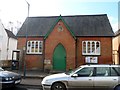
1
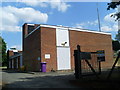
Kimpton Telephone Exchange, Herts
Situated in Hall Lane off High Street, this TE, of standard design, replaced the former, now demolished, TE in High Street in the early 1970s. Besides Kimpton, this TE also serves Blackmore End, Breachwood Green and Peters Green nearby. BT warning notices and a "Thieves Beware" notice can be seen in this photo together with a purple rubbish bin and a yellow grit salt bin. The numbering range of this TE is (01438) 832xxx, the (01438) referring to the Stevenage group of TEs, and its postcode is SG4 8RD.
Image: © David Hillas
Taken: 19 Jul 2013
0.03 miles
4
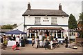
The Boot during the Kimpton Folk Festival
The Boot is a popular venue at the Kimpton Folk Festival.
Image: © Jeff Tomlinson
Taken: 1 Jul 2017
0.05 miles
5

Harvested fields near Kimpton
Taken from Ball Slough Hill on the other side of the valley. The church at Kimpton is just visible in the distance.
Image: © Bikeboy
Taken: 20 Aug 2017
0.10 miles
6

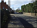
Kimpton: High Street
Kimpton's High Street was not designed for parked cars and 21st century road traffic. Braking to give way to oncoming vehicles in the opposite direction is inevitable.
Image: © Nigel Cox
Taken: 12 Jun 2007
0.11 miles
7
Village hall, Kimpton
The inscription on the foundation stone (bottom left) reads "Erected for the benefit of the men of Kimpton by Susan Lady Dacre, April 15 1879". Lady Dacre was born Susan Sophia Cavendish in 1817. She married Thomas Crosbie William Brand - the 22nd Baron Dacre - in 1837.She died in August 1896. See http://www.hertsmemories.org.uk/page_id__6784_path__.aspx for further details. The clock face bears the inscription "W. Pellant, Harpenden 1892". See http://www.harpenden-history.org.uk/page_id__70_path__0p4p61p.aspx for some information about Pellant, clockmaker and jeweller in Harpenden.
Image: © Bikeboy
Taken: 23 Apr 2013
0.13 miles
8
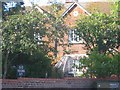
House with an Aviary Kimpton
The wire cage around the window intrigues me
Image: © Jack Hill
Taken: 28 Aug 2005
0.14 miles
9
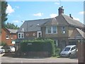
Houses in High Street Kimpton
Interesting to compare the floor heights of the two properties. Victorian versus more recent .
Image: © Jack Hill
Taken: 28 Aug 2005
0.17 miles
10
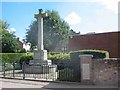
War Memorial High St Kimpton
It seemed worthy to include this in the sequence
Image: © Jack Hill
Taken: 28 Aug 2005
0.17 miles