IMAGES TAKEN NEAR TO
Kings Walden, HITCHIN, SG4 8LS
Introduction
This page details the photographs taken nearby to SG4 8LS by members of the Geograph project.
The Geograph project started in 2005 with the aim of publishing, organising and preserving representative images for every square kilometre of Great Britain, Ireland and the Isle of Man.

There are currently over 7.5m images from over14,400 individuals and you can help contribute to the project by visiting https://www.geograph.org.uk
Image Map
Images are licensed for reuse under creativecommons.org/licenses/by-sa/2.0
Notes
- Clicking on the map will re-center to the selected point.
- The higher the marker number, the further away the image location is from the centre of the postcode.
Image Listing (9 Images Found)
Images are licensed for reuse under creativecommons.org/licenses/by-sa/2.0
Image
Details
Distance
1
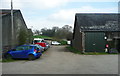
Stopsley Holes Farm, Kings Walden
The public footpath goes straight on between the buildings.
Image: © Humphrey Bolton
Taken: 28 Mar 2017
0.01 miles
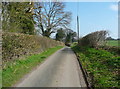
3
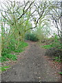
Footpath at Stopsley Holes
This looks like an old lane, sunken in places, but the 1880 1:2500 map shows that it only led to a field and a field path, as it does now.
Image: © Humphrey Bolton
Taken: 28 Mar 2017
0.05 miles
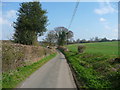
4
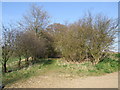
Continuation of the bridleway through Stopsley Holes Farm
Image: © Jeff Tomlinson
Taken: 4 Apr 2007
0.08 miles
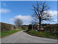
5
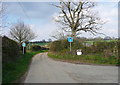
The lane to Stopsley Holes Farm, Kings Walden
A signpost indicates that this is a public road leading to public footpaths.
Image: © Humphrey Bolton
Taken: 28 Mar 2017
0.09 miles
8
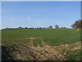
Field at the back of Stopsley Holes Farm
Image: © Jeff Tomlinson
Taken: 4 Apr 2007
0.23 miles
9

Lane to Ley Green, Kings Walden
The hamlet is now in sight, and the first house is on the left.
Image: © Humphrey Bolton
Taken: 28 Mar 2017
0.23 miles