IMAGES TAKEN NEAR TO
Grove Road, HITCHIN, SG4 0AA
Introduction
This page details the photographs taken nearby to Grove Road, SG4 0AA by members of the Geograph project.
The Geograph project started in 2005 with the aim of publishing, organising and preserving representative images for every square kilometre of Great Britain, Ireland and the Isle of Man.

There are currently over 7.5m images from over14,400 individuals and you can help contribute to the project by visiting https://www.geograph.org.uk
Image Map
Images are licensed for reuse under creativecommons.org/licenses/by-sa/2.0
Notes
- Clicking on the map will re-center to the selected point.
- The higher the marker number, the further away the image location is from the centre of the postcode.
Image Listing (33 Images Found)
Images are licensed for reuse under creativecommons.org/licenses/by-sa/2.0
Image
Details
Distance
2
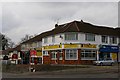
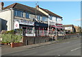
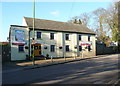
Shops on Grove Road
This small cluster of shops sits at the corner of Grove Road and Cadwell Lane. It includes a cafe, a convenience store, a barber, and a tattoo studio.
Image: © Ben Harris
Taken: 2 Apr 2011
0.03 miles
3
Hitchin: The former Grove Mill
This former corn mill was built at the confluence of the Rivers Hiz and Purwell, and was once possibly known as Burnt Mill. Victorian Ordnance Survey maps show Grove Mill and a large building called Grove House, since demolished, a short distance away up the hill towards Cadwell Lane. The mill has since been converted and is in use today as a nursery, Kinders Mill Nursery http://www.kindersmill.co.uk/page_viewer.asp?page=Home&pid=1
Image: © Nigel Cox
Taken: 13 Jun 2010
0.05 miles
4
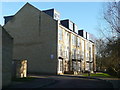
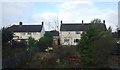
Apartments, Watersmeet off Grove Road
The name 'Watersmeet' refers to the adjacent confluence of the Rivers Hiz and Purwell.
Image: © Humphrey Bolton
Taken: 17 Feb 2015
0.05 miles
5
Kinders Mill Day Nursery
This was Grove Mill (Corn) on the 1881 1:2500 map and is shown as disused on the 1939 edition.
Image: © Humphrey Bolton
Taken: 17 Feb 2015
0.05 miles
6
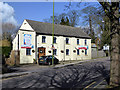
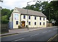
Kinders Mill, Grove Road, Hitchin
An overshot mill, William Lucas is recorded as being the miller in 1613. It was originally called Shotling mill but after a serious fire in 1697, it became known as Burnt Mill. In an act of Parliament in 1757, relating to making the River Ouze navigable, it is referred to as 'Shotling Mill otherwise called Burnt Mill'. It remained in a semi-derelict state (in the ownership of the Crown) until sold to the then tenant, Joseph Ransom in 1813, when it was completely rebuilt as an imposing three-storeyed building with an adjoining house.
As a young girl in the early 1820s, my 3 times great-aunt, Phebe Lucas, attended classes with the Ransom daughters at the Mill House and in her journal she describes it as a 'great treat' to attend school there. However, later in the mid-19th century, there was much litigation between the Ransoms and Hitchin Town because of extreme pollution of the local waterways by the town's sewerage, it being said that, in summer, the house was virtually uninhabitable because of the stench.
The mill was again totally destroyed by fire in 1889. The building in this view is the extended mill house, the main mill building was to its left. The house is now used as a child day-nursery.
Image: © John Lucas
Taken: 27 Feb 2014
0.05 miles
7
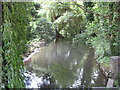
River Purwell at its confluence with the River Hiz
By one of the quirks of geography this is the point at which the smaller River Hiz enters the larger River Purwell over the weir structure bottom right, the Purwell being the watercourse in the main body of the picture. Having captured the Purwell the Hiz then carries on downstream with its own name.
Image: © Nigel Cox
Taken: 13 Jun 2010
0.07 miles
8
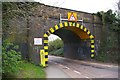
Woolgrove Road railway bridge
This bridge, number SBR-2, carries the Hitchin to Cambridge railway line over Woolgrove Road.
Image: © Ben Harris
Taken: 2 Apr 2011
0.08 miles
9
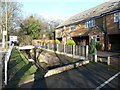
Sentry Court, Grove Road, Hitchin
This block of houses has two bridges over the River Hiz, which here looks rather insignificant and not really deserving the title of 'River'.
Image: © Humphrey Bolton
Taken: 17 Feb 2015
0.08 miles