IMAGES TAKEN NEAR TO
Willow Road, SANDY, SG19 2PP
Introduction
This page details the photographs taken nearby to Willow Road, SG19 2PP by members of the Geograph project.
The Geograph project started in 2005 with the aim of publishing, organising and preserving representative images for every square kilometre of Great Britain, Ireland and the Isle of Man.

There are currently over 7.5m images from over14,400 individuals and you can help contribute to the project by visiting https://www.geograph.org.uk
Image Map
Images are licensed for reuse under creativecommons.org/licenses/by-sa/2.0
Notes
- Clicking on the map will re-center to the selected point.
- The higher the marker number, the further away the image location is from the centre of the postcode.
Image Listing (82 Images Found)
Images are licensed for reuse under creativecommons.org/licenses/by-sa/2.0
Image
Details
Distance
1
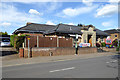
Former school, Potton
Now the Potton & District Club, which seems very popular on a Sunday afternoon. Above the door is inscribed 'Potton Charities Educational Foundation' and then a list of trustees, but no date.
Image: © Robin Webster
Taken: 14 May 2017
0.06 miles
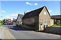
2

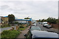
Potton: Station Road
Near the corner of Willow Road on a bright January morning.
Image: © John Sutton
Taken: 7 Jan 2018
0.07 miles
3
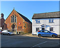
Potton Salvation Army Citadel
The former Methodist Church on Chapel Street has been a Salvation Army Citadel since 1976. The picture was taken from the end of Bull Street. Horslow Street is to the right.
Image: © John Sutton
Taken: 7 Jan 2018
0.07 miles
4
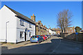
Potton: Horslow Street
A winter-morning view from the corner of Bull Street.
Image: © John Sutton
Taken: 7 Jan 2018
0.08 miles
5
Varsity Line
The Varsity Line connected Oxford and Cambridge and train services ran on the section between Bedford and Cambridge until the end of 1967 https://en.wikipedia.org/wiki/Varsity_Line . Plans are underway to reopen the line in stages between Oxford and Cambridge, and the route is now known as East West Rail.
Some local authorities have taken steps to protect disused rail routes. Hence much of the original alignment between Oxford and Bedford will be/is being reused as it was because it was not built over in the meantime. However, there are several places between Bedford and Cambridge where the old route has been built over, and consequently a completely fresh route is likely to be constructed for this section.
Part of the (second) Potton Station can be seen in the foreground on the left, this now being used as a house. The road straight ahead is Shannon Place. The business premises on the left are built on the alignment of the Varsity Line, which was situated on the far side of the station and ran parallel to Shannon Place. Additional history of the railway and stations in this village may be found from other Geograph contributors and from http://www.disused-stations.org.uk/p/potton/index.shtml
More details of future plans for East West Rail are available from https://www.eastwestrail.org.uk/central-section-overview/
Image: © Andrew Bodman
Taken: 10 Sep 2018
0.09 miles
6
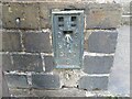
Ordnance Survey Flush Bracket S0170
This bracket can be found on a roadside wall in Station Road, Potton.
The recorded details give a height of 41.7457 metres above sea level.
For more details see : https://www.bench-marks.org.uk/bm12512
Image: © Peter Wood
Taken: 10 Oct 2021
0.09 miles
7

Potton: an old advertisement on Station Road
The faded lettering reads
G.W.Noble.
High Class Tailor
Breeches & Gaiters, Liveries
There is evidence of an earlier layer, of which only the words "Hardware Tailor" are discernible.
Image: © John Sutton
Taken: 7 Jan 2018
0.09 miles
8
Old painted wall, Station Road, Potton
As is often the case, one message appears to have been painted over another. The most legible is 'G.W.Noble High Class Tailors Breeches & Gaiters Liveries'. The last word is indistinct after the 'r', but what else could it be?
Image: © Robin Webster
Taken: 14 May 2017
0.10 miles
9
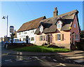
Potton: Moon's Corner and The Royal Oak
The Grade II listed Royal Oak is timber framed and said to be the oldest pub in Potton, dating from the late 18th century. The thatched house is the only one in the Potton Conservation Area - for more about the Conservation Area, try http://www.centralbedfordshire.gov.uk/Images/potton_tcm3-25079.pdf .
Image: © John Sutton
Taken: 7 Jan 2018
0.10 miles
10
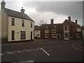
Junction of Biggleswade Road and Chapel Street, Potton
Image: © David Howard
Taken: 31 May 2012
0.10 miles