IMAGES TAKEN NEAR TO
Fakeswell Lane, HENLOW, SG16 6JY
Introduction
This page details the photographs taken nearby to Fakeswell Lane, SG16 6JY by members of the Geograph project.
The Geograph project started in 2005 with the aim of publishing, organising and preserving representative images for every square kilometre of Great Britain, Ireland and the Isle of Man.

There are currently over 7.5m images from over14,400 individuals and you can help contribute to the project by visiting https://www.geograph.org.uk
Image Map
Images are licensed for reuse under creativecommons.org/licenses/by-sa/2.0
Notes
- Clicking on the map will re-center to the selected point.
- The higher the marker number, the further away the image location is from the centre of the postcode.
Image Listing (29 Images Found)
Images are licensed for reuse under creativecommons.org/licenses/by-sa/2.0
Image
Details
Distance
1
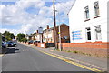
The Indian Ocean Tandoori, Fakeswell Lane, Lower Stondon
This Tandoori Restaurant used to be the Twist and Cheese public house, how things have changed.
Image: © Mick Malpass
Taken: 28 Aug 2012
0.02 miles

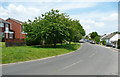
3
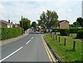
Fakeswell Lane, Lower Stondon
This housing estate road has been made on the route of a bridleway, although there were already houses along it on the 1882 OS map.
Image: © Humphrey Bolton
Taken: 12 Jul 2014
0.06 miles
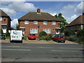
5
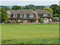
Houses with mansard roofs, Lower Stondon
Image: © Humphrey Bolton
Taken: 12 Jul 2014
0.08 miles
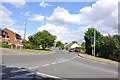
6

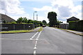
Mayfield Crescent at the junction of Station Road
Image: © David Howard
Taken: 16 Jan 2022
0.08 miles
7
Junction of Fakeswell Lane and Hawthorn Way, Lower Stondon, Beds
Everything to the left of this stretch of Fakeswell Lane in the 1960's was farming land, growing corn etc.
Image: © Mick Malpass
Taken: 28 Aug 2012
0.08 miles
9
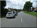
Station Road, Lower Stondon
Looking south west.
Image: © JThomas
Taken: 15 Aug 2015
0.10 miles
10
Station Road, Lower Stondon
This road name goes all the way to the A600, and the station was to the east of that road.
Image: © Humphrey Bolton
Taken: 12 Jul 2014
0.10 miles