IMAGES TAKEN NEAR TO
Primary Way, ARLESEY, SG15 6YE
Introduction
This page details the photographs taken nearby to Primary Way, SG15 6YE by members of the Geograph project.
The Geograph project started in 2005 with the aim of publishing, organising and preserving representative images for every square kilometre of Great Britain, Ireland and the Isle of Man.

There are currently over 7.5m images from over14,400 individuals and you can help contribute to the project by visiting https://www.geograph.org.uk
Image Map
Images are licensed for reuse under creativecommons.org/licenses/by-sa/2.0
Notes
- Clicking on the map will re-center to the selected point.
- The higher the marker number, the further away the image location is from the centre of the postcode.
Image Listing (17 Images Found)
Images are licensed for reuse under creativecommons.org/licenses/by-sa/2.0
Image
Details
Distance
1
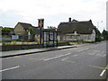
Arlesey: The former Three Tuns
Only a little over four years on from Robin's Image and the pub has joined the remorseless and seemingly irreversible trend of closures. Even the building's Grade II Listed status has failed to save it. The English Heritage Listed Buildings website describes it thus:-
"18th Century. Timber framed construction with colourwashed roughcast render. Thatched roof, half-hipped to W end. 3-room plan, one storey and attics, gable end to road. Variety of casement windows, all small with glazing bars. Eyebrow dormer to N elevation. 20th Century porch to N elevation. Red brick chimney stacks, one to ridge, one to each gable end. Single storeyed addition adjoins to E gable end, weatherboarded and thatched, with casement windows."
The north elevation with the eyebrow dormer is this one.
Comparing the older image with this one the other obvious change is the erection of the bus shelter in the period since 2005.
Image: © Nigel Cox
Taken: 13 Jun 2010
0.04 miles
2
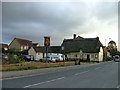
The Three Tuns
Right on the edge of the square, The Three Tuns is one of two pubs in it. The buildings behind are new houses. This village has seen a lot of development in the last couple of years.
Image: © Robin Hall
Taken: 30 Oct 2005
0.05 miles
3
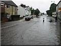
Flash flood
Heavy rain caused a flash flood this afternoon. Photo taken from the junction of Chapel Drive and High Street at 3:42 pm after about twenty minutes torrential rain.
Image: © Malcolm Campbell
Taken: 9 Aug 2004
0.05 miles
4
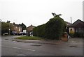
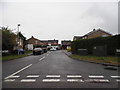
High Street Arlesey at the corner of Cricketer's Road
Image: © David Howard
Taken: 12 May 2018
0.06 miles
6
Arlesey Methodist Church
The Church is on the west side of the High Street and was opened in 1981 at a cost of £85,000.
Image: © Nigel Cox
Taken: 13 Jun 2010
0.14 miles
7
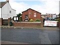
Arlesey: The Women's Institute Hall
The WI will celebrate its 100th anniversary in 2015, having been founded in 1915 with two fundamental aims, both related to the then ongoing First World War, firstly to increase the quantity and improve the quality of food production, and secondly to revitalise rural communities where there was a sudden decrease in the number of men available for working on the land.
This is the Arlesey WI hall on the east side of the High Street. The building was gutted in a fire in 1981 but reopened in 1983.
Image: © Nigel Cox
Taken: 13 Jun 2010
0.16 miles
8
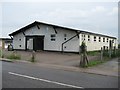
W. I. Hall Arlesey
A child's birthday party taking place at the W. I. Hall.
Image: © Jeff Tomlinson
Taken: 24 Feb 2018
0.16 miles
9
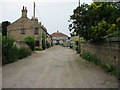
Davis Row
Just one motor vehicle on a normally busy mud track. Previously known as Paradise Row. The home in the foreground to the left was The Stag Public House which opened in 1868 and closed in 1926.
Image: © Malcolm Campbell
Taken: 5 Jul 2006
0.17 miles
10
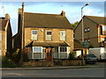
The house that we might have bought.
For a variety of reasons we didn't. This is typical of the houses in Arlesey. Note the light coloured brick. This is made from clay dug locally and turned into bricks by a (largely) italian immigrant workforce near to the village.
Image: © Robin Hall
Taken: 30 Oct 2005
0.17 miles