IMAGES TAKEN NEAR TO
Brickendon Lane, HERTFORD, SG13 8NY
Introduction
This page details the photographs taken nearby to Brickendon Lane, SG13 8NY by members of the Geograph project.
The Geograph project started in 2005 with the aim of publishing, organising and preserving representative images for every square kilometre of Great Britain, Ireland and the Isle of Man.

There are currently over 7.5m images from over14,400 individuals and you can help contribute to the project by visiting https://www.geograph.org.uk
Image Map (Loading...)


Getting Data...Please wait
Leaflet Map data © OpenStreetMap
Images are licensed for reuse under creativecommons.org/licenses/by-sa/2.0
Notes
- Clicking on the map will re-center to the selected point.
- The higher the marker number, the further away the image location is from the centre of the postcode.
Image Listing (8 Images Found)
Images are licensed for reuse under creativecommons.org/licenses/by-sa/2.0
Image
Details
Distance
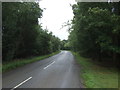
4
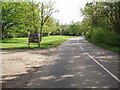
Turning for the Celtic Harmony Camp
See http://www.celticharmony.org/ for more information. Strangely named, it is a mixture of things iron age and hippy love and peace. Worth a visit.
Image: © Bikeboy
Taken: 13 May 2012
0.09 miles
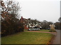
5
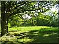
Small green, Brickendon
Public access, so probably registered common land.
Image: © Robin Webster
Taken: 24 May 2016
0.12 miles
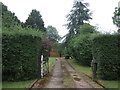
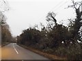
7
Track leading to Celtic Harmony Camp, Brickendon
Track leading from Brickendon Lane to the Celtic Harmony Camp the gate on the right leads through to Bourne Orchard
Image: © Christine Matthews
Taken: 29 Jan 2006
0.14 miles