IMAGES TAKEN NEAR TO
Rush Green, HERTFORD, SG13 7SD
Introduction
This page details the photographs taken nearby to SG13 7SD by members of the Geograph project.
The Geograph project started in 2005 with the aim of publishing, organising and preserving representative images for every square kilometre of Great Britain, Ireland and the Isle of Man.

There are currently over 7.5m images from over14,400 individuals and you can help contribute to the project by visiting https://www.geograph.org.uk
Image Map
Images are licensed for reuse under creativecommons.org/licenses/by-sa/2.0
Notes
- Clicking on the map will re-center to the selected point.
- The higher the marker number, the further away the image location is from the centre of the postcode.
Image Listing (25 Images Found)
Images are licensed for reuse under creativecommons.org/licenses/by-sa/2.0
Image
Details
Distance
1
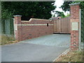
Rush Green Hall
A view showing the carved name signs in each of the brick piers.
Image: © Rob Candlish
Taken: 26 Jul 2010
0.01 miles
2
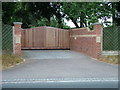
Entrance to Rush Green Hall
Rush Green Hall is marked on the 1:25,000 Ordnance Survey Explorer series map as Rush Green Lodge.
Image: © Rob Candlish
Taken: 26 Jul 2010
0.01 miles
3
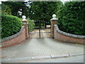
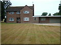
Rush Green House
Entrance to Rush Green House.
Image: © Rob Candlish
Taken: 26 Jul 2010
0.02 miles
4
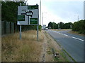
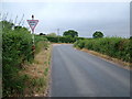
Road sign on the approach to Rush Green Roundabout
Like Amwell Roundabout, Rush Green Roundabout also has a grid square boundary passing through it. The white van at the head of the queue of traffic waiting to get onto the roundabout is just about to enter grid square Image
Image: © Rob Candlish
Taken: 26 Jul 2010
0.05 miles
5
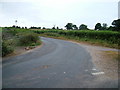
Junction of Downfield Road and Rush Green Lane
Looking along Downfield Road towards its junction with Rush Green Lane.
The give way sign here seems somewhat out of place since the road markings on the junction require traffic coming from the road on the left to give way. The corner in the road dead ahead is a notorious accident spot, especially in icy weather.
Image: © Rob Candlish
Taken: 26 Jul 2010
0.06 miles
6
Junction of Rush Green Lane and Downfield Road
The road markings on this junction (which are only just visible) are at variance with the traffic sign in Downfield Road on the other side of the junction which tells approaching drivers to give way.
Image: © Rob Candlish
Taken: 26 Jul 2010
0.07 miles
7
Pondcroft, Rush Green Lane
Almost opposite Rush Green House in Rush Green Lane.
Image: © Rob Candlish
Taken: 26 Jul 2010
0.07 miles
8
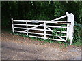
Five barred gate
The entrance to Pondcroft, a house in Rush Green Lane.
Image: © Rob Candlish
Taken: 26 Jul 2010
0.08 miles
9
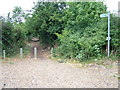
Public footpath near Rush Green Roundabout
This public footpath to Rush Green and Hertford Heath follows part of the course of an old Roman Road, Ermine Street.
Image: © Rob Candlish
Taken: 26 Jul 2010
0.09 miles
10
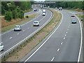
Traffic on the A10
A view from Rush Green Roundabout, with Hoe Lane bridge in the background.
Image: © Rob Candlish
Taken: 26 Jul 2010
0.11 miles