IMAGES TAKEN NEAR TO
Brookside, HERTFORD, SG13 7LL
Introduction
This page details the photographs taken nearby to Brookside, SG13 7LL by members of the Geograph project.
The Geograph project started in 2005 with the aim of publishing, organising and preserving representative images for every square kilometre of Great Britain, Ireland and the Isle of Man.

There are currently over 7.5m images from over14,400 individuals and you can help contribute to the project by visiting https://www.geograph.org.uk
Image Map
Images are licensed for reuse under creativecommons.org/licenses/by-sa/2.0
Notes
- Clicking on the map will re-center to the selected point.
- The higher the marker number, the further away the image location is from the centre of the postcode.
Image Listing (5 Images Found)
Images are licensed for reuse under creativecommons.org/licenses/by-sa/2.0
Image
Details
Distance
1
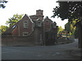
Balls Park - north lodge
Balls Park was formerly a teacher training college in extensive grounds. As of 2011 a large residential development was being built on the site (hence the excavator seen here behind the lodge).
The road in the foreground is the old course of London Road - now bypassed by the A414 trunk road and a dead end except for this entrance to Balls Park, and a cycle route.
Image: © Stephen Craven
Taken: 4 Jun 2011
0.13 miles
2
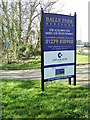
Balls Park developers sign
Developer's sign at the junction of London Road and the A414 announcing their acquisition of Balls Park, a Grade One listed building once a campus of The University of Hertfordshire and where I studied for my degree.
Image: © Rob Candlish
Taken: 16 Mar 2005
0.15 miles
3
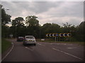
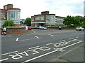
Foxholes roundabout on the A414, Hertford
Image: © David Howard
Taken: 13 Jun 2012
0.16 miles
4
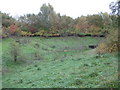
Hertford: Braziers Field Flood Storage Area
Management of watercourses to alleviate the effects of flooding often entails building flood storage areas where the water can be impounded and let down the stream or river in a controlled manner. This small storage area impounds water from Braziers Field Drain. 1960s Ordnance Survey maps show that the drain then ran in an open channel down Braziers Field road, before joining with Rowleys Road Drain at the top end of Foxholes Avenue. The joined up stream then ran down the middle of that road. Today most of the watercourses in this area are culverted and out of sight.
Image: © Nigel Cox
Taken: 29 Oct 2010
0.23 miles
5
Ware Road, Hertford
Entrance to the former Addis brush factory, known to generations of Hertfordians simply as "The brushworks". Now converted into offices, a small retail park and residential accommodation.
A splendid piece of 1930s "international style" architecture of the type popularised in Europe by Walter Gropius and Le Corbusier in the 1930s and which still has a contemporary look to it today.
Image: © Rob Candlish
Taken: 12 Jul 2010
0.24 miles