IMAGES TAKEN NEAR TO
Ware Road, HERTFORD, SG13 7HE
Introduction
This page details the photographs taken nearby to Ware Road, SG13 7HE by members of the Geograph project.
The Geograph project started in 2005 with the aim of publishing, organising and preserving representative images for every square kilometre of Great Britain, Ireland and the Isle of Man.

There are currently over 7.5m images from over14,400 individuals and you can help contribute to the project by visiting https://www.geograph.org.uk
Image Map (Loading...)


Getting Data...Please wait
Leaflet Map data © OpenStreetMap
Images are licensed for reuse under creativecommons.org/licenses/by-sa/2.0
Notes
- Clicking on the map will re-center to the selected point.
- The higher the marker number, the further away the image location is from the centre of the postcode.
Image Listing (91 Images Found)
Images are licensed for reuse under creativecommons.org/licenses/by-sa/2.0
Image
Details
Distance
1
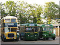
Three old buses
These were parked incongruously in the car park of the fire station Image
Image: © Stephen Craven
Taken: 4 Jun 2011
0.02 miles
2
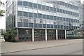
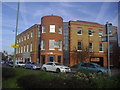
Hertford fire station
Hertford fire station, Old London Road, Hertford, Hertfordshire, which forms part of the Headquarters complex of the Hertfordshire Fire & Rescue Service Image
Image: © Kevin Hale
Taken: 7 Oct 2007
0.03 miles
4
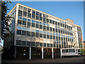
Hertfordshire Fire & Rescue Service Headquarters
Hertfordshire Fire & Rescue Service HQ, Old London Road, Hertford, Hertfordshire, which also includes Hertford fire station Image
Image: © Kevin Hale
Taken: 7 Oct 2007
0.03 miles
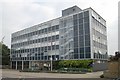
5
Hertford Fire Station
The building is on Old London Road. See also Image
Image: © Stephen Craven
Taken: 4 Jun 2011
0.04 miles
7
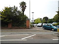
The entrance to Tesco on Ware Road, Hertford
Image: © David Howard
Taken: 10 Jul 2014
0.06 miles

9
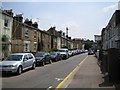
Hertford: Villiers Street
This street, and the parallel one to the east, Townshend Street, are named after John Villiers Townshend, 5th Marquis of Salisbury. Curiously the 1884 Ordnance Survey map shows them both as "Road" rather than "Street".
Image: © Nigel Cox
Taken: 21 Jul 2006
0.08 miles
10
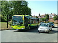
Bluecoats Roundabout, Hertford
Arriva East Herts & Essex 3902 on a 724 journey to Heathrow at Bluecoats Roundabout, Hertford, so named because of the former Christ's Hospital School whose old buildings can be seen in the background. Ware Road is out of shot to the right.
Image: © Rob Candlish
Taken: 9 Aug 2010
0.09 miles