IMAGES TAKEN NEAR TO
Ware Road, HERTFORD, SG13 7EW
Introduction
This page details the photographs taken nearby to Ware Road, SG13 7EW by members of the Geograph project.
The Geograph project started in 2005 with the aim of publishing, organising and preserving representative images for every square kilometre of Great Britain, Ireland and the Isle of Man.

There are currently over 7.5m images from over14,400 individuals and you can help contribute to the project by visiting https://www.geograph.org.uk
Image Map (Loading...)


Getting Data...Please wait
Leaflet Map data © OpenStreetMap
Images are licensed for reuse under creativecommons.org/licenses/by-sa/2.0
Notes
- Clicking on the map will re-center to the selected point.
- The higher the marker number, the further away the image location is from the centre of the postcode.
Image Listing (84 Images Found)
Images are licensed for reuse under creativecommons.org/licenses/by-sa/2.0
Image
Details
Distance
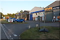
1
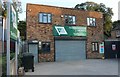
GSS Group, Ware
They are an engineering company, Geostructural Solutions. https://www.geostructuralsolutions.co.uk/
Image: © David Howard
Taken: 21 Sep 2019
0.01 miles
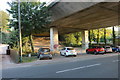
3

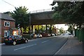
A10 flyover, Hertford
The A10 goes over Ware Road
Image: © David Howard
Taken: 24 Mar 2011
0.02 miles
4
The A10 crossing Hertford Road
Leaving the Ware border into Hertford
Image: © David Howard
Taken: 21 Sep 2019
0.03 miles
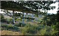
5
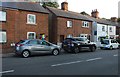
Car parking under the Ware Viaduct on Hertford Road
Image: © David Howard
Taken: 21 Sep 2019
0.04 miles
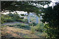
6
Windsor Industrial Estate, Ware
This may not be the smallest industrial estate in the country but must be one of them, this is the entire site.
Image: © David Howard
Taken: 21 Sep 2019
0.04 miles
9
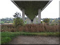
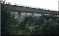
A10 Kingsmead Viaduct (2)
This 19 span 2¼ mile long viaduct, variously known as the Kingsmead, King's Meads or Ware Viaduct, was opened in 1976 at a cost of £3.6 million, and carries the A10 over the valley of the River Lee. It is said to be 65 feet high above the ground at its highest point. This is the view looking southwards from The New River. For a view in the opposite direction please see Image
Image: © Nigel Cox
Taken: 29 Oct 2010
0.09 miles