IMAGES TAKEN NEAR TO
Swift Close, WARE, SG12 8TZ
Introduction
This page details the photographs taken nearby to Swift Close, SG12 8TZ by members of the Geograph project.
The Geograph project started in 2005 with the aim of publishing, organising and preserving representative images for every square kilometre of Great Britain, Ireland and the Isle of Man.

There are currently over 7.5m images from over14,400 individuals and you can help contribute to the project by visiting https://www.geograph.org.uk
Image Map (Loading...)


Getting Data...Please wait
Leaflet Map data © OpenStreetMap
Images are licensed for reuse under creativecommons.org/licenses/by-sa/2.0
Notes
- Clicking on the map will re-center to the selected point.
- The higher the marker number, the further away the image location is from the centre of the postcode.
Image Listing (20 Images Found)
Images are licensed for reuse under creativecommons.org/licenses/by-sa/2.0
Image
Details
Distance
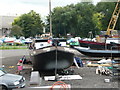
1
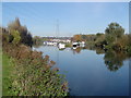
River Lee Navigation: Marina, Stanstead St. Margarets
Viewed looking northwards from under the A414 road bridge, the channel to the left is the Navigation, the channel to the right is Stanstead Mill Stream.
Image: © Nigel Cox
Taken: 19 Nov 2005
0.05 miles
2
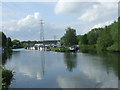
River Lea at St. Margaret's
The River Lee Navigation (to the left) and the River Lea (or Lee, to the right) rejoin here at St. Margaret's.
Image: © Malc McDonald
Taken: 1 Jun 2013
0.05 miles
3
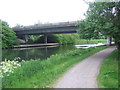
River Lee near St. Margaret's
The River Lea (or Lee) near St. Margaret's, in Hertfordshire. The concrete bridge carries the trunk A414 road across the river.
The towpath is a shared path for cycling and walking.
Image: © Malc McDonald
Taken: 1 Jun 2013
0.12 miles

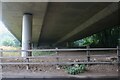
5
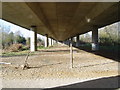
Under the A414 road
The underside of the road viaduct carrying the A414 over the River Lee Navigation.
Image: © Nigel Cox
Taken: 19 Nov 2005
0.17 miles
6
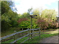
Footpath sign and junction at Rye Meads Nature Reserve
Image: © PAUL FARMER
Taken: 13 Oct 2012
0.20 miles
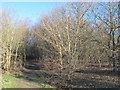
8
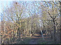
Woodland east of the New River south of Rye Common Pumping Station
See Image
Image: © Mike Quinn
Taken: 14 Jan 2015
0.21 miles
10
Under Ware
Hoddesdon Road going under the A414. It's actually a couple of miles south of Ware but the pun wouldn't have worked then.
Image: © David Howard
Taken: 25 Jul 2021
0.22 miles