IMAGES TAKEN NEAR TO
High Street, WARE, SG12 8SZ
Introduction
This page details the photographs taken nearby to High Street, SG12 8SZ by members of the Geograph project.
The Geograph project started in 2005 with the aim of publishing, organising and preserving representative images for every square kilometre of Great Britain, Ireland and the Isle of Man.

There are currently over 7.5m images from over14,400 individuals and you can help contribute to the project by visiting https://www.geograph.org.uk
Image Map
Images are licensed for reuse under creativecommons.org/licenses/by-sa/2.0
Notes
- Clicking on the map will re-center to the selected point.
- The higher the marker number, the further away the image location is from the centre of the postcode.
Image Listing (21 Images Found)
Images are licensed for reuse under creativecommons.org/licenses/by-sa/2.0
Image
Details
Distance
1
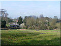
View from Nether Street, Widford
Ashbourne Manor is mostly hiding behind the trees towards the left.
Image: © Robin Webster
Taken: 13 Mar 2014
0.02 miles
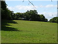
2
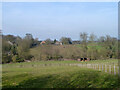
View from Nether Street, Widford
Looking towards The Bungalows.
Image: © Robin Webster
Taken: 13 Mar 2014
0.06 miles
5
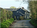
Hawthorn Cottage, Nether Street, Widford
Image: © Robin Webster
Taken: 13 Mar 2014
0.12 miles
6
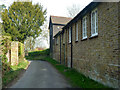
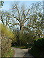
Nether Street, Widford
On the right are 18th century outbuildings attached to the earlier Barnfield house, and seemingly included in its grade II listing.
Image: © Robin Webster
Taken: 13 Mar 2014
0.12 miles
9
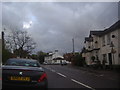
The Green Man at Widford: 1997
Situated in the High Street.
Image: © John Baker
Taken: 28 Mar 1997
0.17 miles
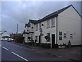
10
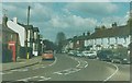
High Street Widford
The Green Man pub is on the right, the junction for Hunsdon straight ahead.
Image: © David Howard
Taken: 25 Apr 2012
0.17 miles