IMAGES TAKEN NEAR TO
Wareside, WARE, SG12 7RB
Introduction
This page details the photographs taken nearby to SG12 7RB by members of the Geograph project.
The Geograph project started in 2005 with the aim of publishing, organising and preserving representative images for every square kilometre of Great Britain, Ireland and the Isle of Man.

There are currently over 7.5m images from over14,400 individuals and you can help contribute to the project by visiting https://www.geograph.org.uk
Image Map (Loading...)


Getting Data...Please wait
Leaflet Map data © OpenStreetMap
Images are licensed for reuse under creativecommons.org/licenses/by-sa/2.0
Notes
- Clicking on the map will re-center to the selected point.
- The higher the marker number, the further away the image location is from the centre of the postcode.
Image Listing (5 Images Found)
Images are licensed for reuse under creativecommons.org/licenses/by-sa/2.0
Image
Details
Distance

3
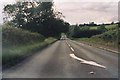
B1004 between Widford and Wareside
A view of the only straight section of road between Much Hadham and Ware. Looking westwards.
Image: © Simon Davies
Taken: Unknown
0.19 miles
4
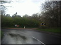
Bend on Ware Road past Widford
The entrance on the right appears to be for a waste disposal site from memory. It was not there on the Streetview page so clearly a new development.
Image: © David Howard
Taken: 25 Apr 2012
0.22 miles