IMAGES TAKEN NEAR TO
High Oak Road, WARE, SG12 7NX
Introduction
This page details the photographs taken nearby to High Oak Road, SG12 7NX by members of the Geograph project.
The Geograph project started in 2005 with the aim of publishing, organising and preserving representative images for every square kilometre of Great Britain, Ireland and the Isle of Man.

There are currently over 7.5m images from over14,400 individuals and you can help contribute to the project by visiting https://www.geograph.org.uk
Image Map (Loading...)


Getting Data...Please wait
Leaflet Map data © OpenStreetMap
Images are licensed for reuse under creativecommons.org/licenses/by-sa/2.0
Notes
- Clicking on the map will re-center to the selected point.
- The higher the marker number, the further away the image location is from the centre of the postcode.
Image Listing (14 Images Found)
Images are licensed for reuse under creativecommons.org/licenses/by-sa/2.0
Image
Details
Distance
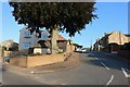
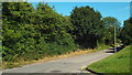
3

Musley Hill, Ware
On the northern edge of town.
Image: © Robin Webster
Taken: 17 Feb 2019
0.05 miles
4
Ware: The Bourne
A bourne is an intermittent stream that only flows when the level of the water table in the ground reaches the surface or when there has been sufficient rainfall to saturate the surrounding land. Most have prefixed names such as "Winter Bourne", but this one is just The Bourne, and the watercourse only runs for a couple of kilometres before joining the River Lee in Ware. At the end of October 2010 the stream bed was totally dry.
Image: © Nigel Cox
Taken: 29 Oct 2010
0.06 miles
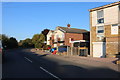
6
Fanhams Hall Road, Ware
Fanhams Hall Road on the edge of the town of Ware in Hertfordshire.
Image: © Malc McDonald
Taken: 3 Aug 2013
0.07 miles
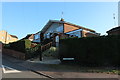
7
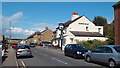
The Crooked Billet, Ware
The Crooked Billet pub in Ware, Hertfordshire.
Image: © Malc McDonald
Taken: 3 Aug 2013
0.10 miles
9
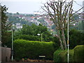
Water Tower in Tower Road
This photo was actually taken with a long lens in Walton Road, Ware at TL359138 and looks over two other grid squares (TL3614 and TL3615). The principal feature is the water tower on the horizon and in grid square TL3615, which gives Tower Road on the other side of the town its name.
The photo also emphasises that the centre of Ware stands at the bottom of the Lea Valley. Modern housing built in the 1950s and 1960s has encroached up the valley sides to both the north and south of the town though.
Image: © Rob Candlish
Taken: 26 Jul 2010
0.17 miles
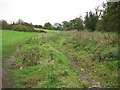
10
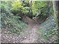
Ware: The Bourne
A bourne is an intermittent stream that only flows when the level of the water table in the ground reaches the surface or when there has been sufficient rainfall to saturate the surrounding land. Most have prefixed names such as "Winter Bourne", but this one is just The Bourne, and the watercourse only runs for a couple of kilometres before joining the River Lee in Ware. At the end of October 2010 the stream bed was totally dry.
It runs here in an incised wooded valley that is quite deep, about 5 metres, compared to the reach just a couple of hundred metres further upstream Image
Image: © Nigel Cox
Taken: 29 Oct 2010
0.17 miles